AI-Powered Aerial Robots Revolutionize Wildfire Smoke Analysis
3 Sources
3 Sources
[1]
AI-powered aerial robots capture wildfire smoke data with precision
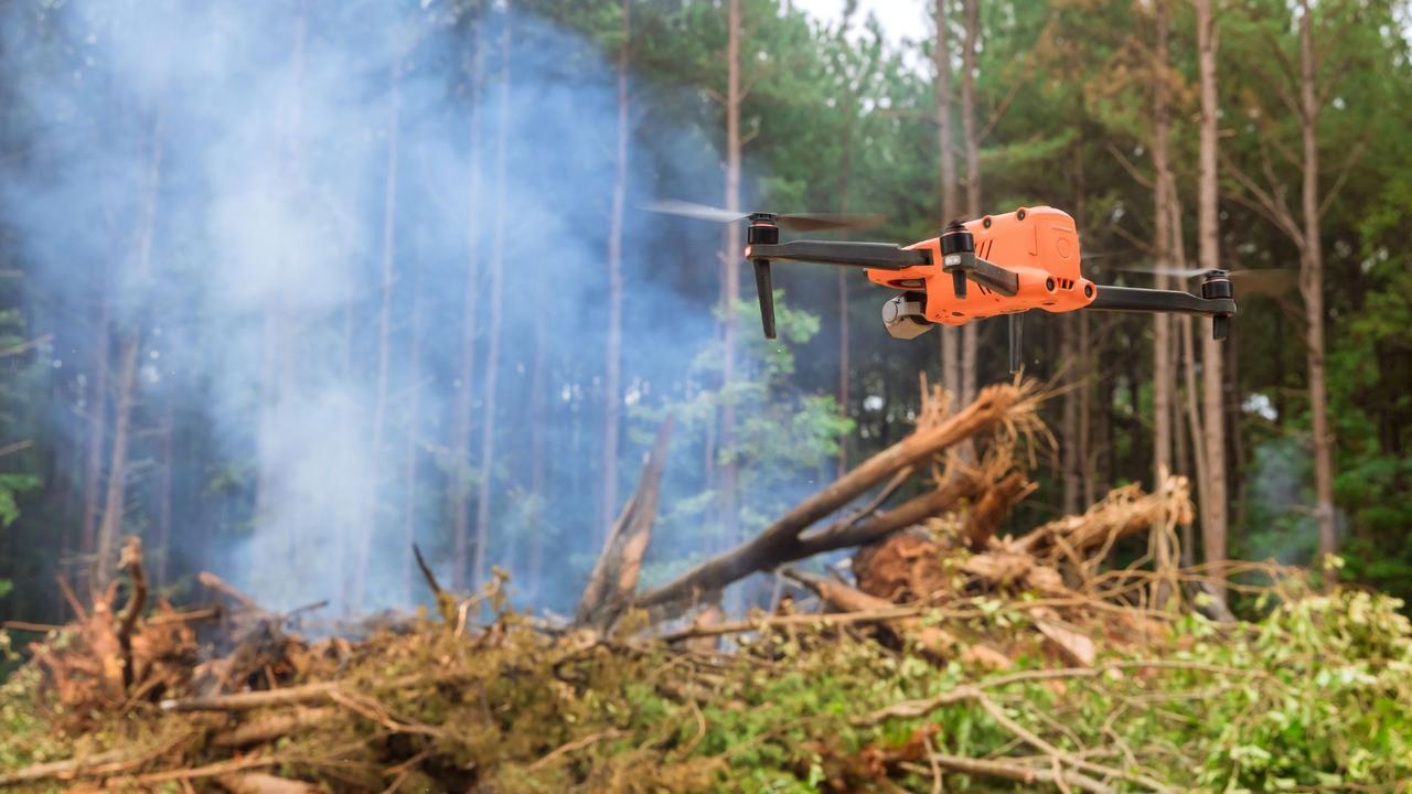
The team's work combines artificial intelligence with coordinated drone swarms. The compact machines detect, track, and map smoke plumes in real time. By doing so, they provide scientists with detailed information to improve models of how pollutants move through the atmosphere. They equipped a swarm of aerial robots with sensors and AI. Unlike traditional drones, these robots can recognize smoke and fly into it. They collect data from multiple angles and build 3D reconstructions of plumes. This approach helps scientists study how smoke particles move and disperse. "A key step is understanding the composition of smoke particles and how they disperse," said Jiarong Hong, professor in the Department of Mechanical Engineering and senior author. He explained that smaller particles can travel longer distances and remain suspended for extended periods. This can affect air quality far from the original fire. The aerial robots offer advantages over satellites. "This approach allows for high-resolution data collection across large areas -- at a lower cost than satellite-based tools," said Nikil Nrishnakumar, graduate research assistant at the Minnesota Robotics Institute and first author. "It provides critical data for improving simulations and informing hazard response."
[2]
AI-equipped aerial robots help track and model wildfire smoke
Researchers at the University of Minnesota Twin Cities have developed aerial robots equipped with artificial intelligence (AI) to detect, track and analyze wildfire smoke plumes. This innovation could lead to more accurate computer models that will improve air quality predictions for a wide range of pollutants. The research was recently published in Science of the Total Environment. According to a 2024 Associated Press report, 43 wildfires resulted from 50,000 prescribed burns between 2012 and 2021, creating the need for better smoke management tools. Previous simulation tools have worked to model fire and smoke particle behavior, but there were still limitations in accurate collection of data, modeling and the current field tools to observe these smoke plumes. In this paper, the researchers addressed the challenges in accurately modeling how smoke particles behave and spread during wildfires and prescribed burns. "A key step is understanding the composition of smoke particles and how they disperse," said Jiarong Hong, a professor in the University of Minnesota's Department of Mechanical Engineering and senior author on the paper. "Smaller particles can travel farther and stay suspended longer, impacting regions far from the original fire." Using a swarm of AI-guided aerial robots, they were able to capture multiple angles of the smoke plumes to create 3D reconstructions of smoke plumes and analyze flow patterns. Unlike traditional drones, these aerial robots can identify smoke and navigate into it to collect data. "This approach allows for high-resolution data collection across large areas -- at a lower cost than satellite-based tools," said Nikil Nrishnakumar, a graduate research assistant with the Minnesota Robotics Institute at the University of Minnesota and first author of the paper. "It provides critical data for improving simulations and informing hazard response." The cost-effective technology has potential beyond wildfires and could be adapted for sandstorms, volcanic eruptions, and other airborne hazards. The team's next goal is to translate the research into practical tools for early fire detection and mitigation. "Early identification is key," Hong said. "The sooner you can see the fire, the faster you can respond." Previously, the team developed an autonomous drone system, equipped with onboard computer vision and sensors to detect and track wildfire smoke plumes in real time. Building on this, they will now be focusing on efficient plume tracking and particle characterization using Digital Inline Holography with coordinated multi-drone systems. They are also working on integrating a type of drone, called a fixed-wing VTOL (Vertical Takeoff and Landing), that can take off without a runway and can fly for more than an hour for extended-range surveillance missions. In addition to Hong and Nrishnakumar, the team included Shashank Sharma and Srijan Kumar Pal from the Minnesota Robotics Institute. This work was done with the help of St. Anthony Falls Laboratory.
[3]
AI-Equipped Aerial Robots Help to Track and Model Wildfire Smoke | Newswise
Newswise -- MINNEAPOLIS / ST. PAUL (09/02/2025) -- Researchers at the University of Minnesota Twin Cities have developed aerial robots equipped with artificial intelligence (AI) to detect, track and analyze wildfire smoke plumes. This innovation could lead to more accurate computer models that will improve air quality predictions for a wide range of pollutants. The research was recently published in Science of the Total Environment, a peer-reviewed scientific journal. According to a 2024 Associated Press report, 43 wildfires resulted from 50,000 prescribed burns between 2012 and 2021, creating the need for better smoke management tools. Previous simulation tools have worked to model fire and smoke particle behavior, but there were still limitations in accurate collection of data, modeling and the current field tools to observe these smoke plumes. In this paper, the researchers addressed the challenges in accurately modeling how smoke particles behave and spread during wildfires and prescribed burns. "A key step is understanding the composition of smoke particles and how they disperse," said Jiarong Hong, a professor in the University of Minnesota's Department of Mechanical Engineering and senior author on the paper. "Smaller particles can travel farther and stay suspended longer, impacting regions far from the original fire." Using a swarm of AI-guided aerial robots, they were able to capture multiple angles of the smoke plumes to create 3D reconstructions of smoke plumes and analyze flow patterns. Unlike traditional drones, these aerial robots can identify smoke and navigate into it to collect data. The cost-effective technology has potential beyond wildfires and could be adapted for sandstorms, volcanic eruptions, and other airborne hazards. The team's next goal is to translate the research into practical tools for early fire detection and mitigation. "Early identification is key," Hong said. "The sooner you can see the fire, the faster you can respond." Previously, the team developed an autonomous drone system, equipped with onboard computer vision and sensors to detect and track wildfire smoke plumes in real time. Building on this, they will now be focusing on efficient plume tracking and particle characterization using Digital Inline Holography with coordinated multi-drone systems. They are also working on integrating a type of drone, called a fixed-wing VTOL (Vertical Takeoff and Landing), that can take off without a runway and can fly for more than an hour for extended-range surveillance missions. In addition to Hong and Nrishnakumar, the team included Shashank Sharma and Srijan Kumar Pal from the Minnesota Robotics Institute. The paper was supported by the National Science Foundation Major Research Instrumentation program. This work was done with the help of the St. Anthony Falls Laboratory.
Share
Share
Copy Link
University of Minnesota researchers develop AI-equipped drones to track and model wildfire smoke, potentially improving air quality predictions and hazard response.
Innovative AI-Powered Drones for Wildfire Smoke Analysis
Researchers at the University of Minnesota Twin Cities have developed a groundbreaking technology that combines artificial intelligence (AI) with aerial robotics to revolutionize the study of wildfire smoke plumes. This innovative approach addresses the critical need for better smoke management tools, especially in light of recent statistics showing that 43 wildfires resulted from 50,000 prescribed burns between 2012 and 2021
2
.Advanced Capabilities of AI-Guided Aerial Robots
Source: Interesting Engineering
The team has equipped a swarm of aerial robots with sensors and AI, enabling them to detect, track, and map smoke plumes in real-time
1
. Unlike traditional drones, these robots can recognize smoke and fly into it, collecting data from multiple angles to build 3D reconstructions of plumes1
2
. This approach provides scientists with detailed information to improve models of how pollutants move through the atmosphere.Improving Air Quality Predictions and Hazard Response
Professor Jiarong Hong, senior author of the study, emphasizes the importance of understanding smoke particle composition and dispersion. "Smaller particles can travel farther and stay suspended longer, impacting regions far from the original fire," he explains
2
3
. The high-resolution data collected by these aerial robots across large areas offers a cost-effective alternative to satellite-based tools, providing critical information for improving simulations and informing hazard response1
2
.Potential Applications Beyond Wildfires

Source: Tech Xplore
The cost-effective technology developed by the University of Minnesota team has potential applications beyond wildfires. It could be adapted for monitoring and analyzing other airborne hazards such as sandstorms and volcanic eruptions
2
3
. The researchers are now focusing on translating their findings into practical tools for early fire detection and mitigation.Related Stories

Future Developments and Ongoing Research
Building on their previous work with autonomous drone systems, the team is now concentrating on efficient plume tracking and particle characterization using Digital Inline Holography with coordinated multi-drone systems
2
3
. They are also working on integrating fixed-wing Vertical Takeoff and Landing (VTOL) drones, which can take off without a runway and fly for extended periods, enhancing long-range surveillance capabilities2
3
.Collaborative Effort and Funding
The research team, led by Professor Jiarong Hong and graduate research assistant Nikil Nrishnakumar, includes Shashank Sharma and Srijan Kumar Pal from the Minnesota Robotics Institute
2
3
. Their work, supported by the National Science Foundation Major Research Instrumentation program and conducted with assistance from the St. Anthony Falls Laboratory, represents a significant step forward in environmental monitoring and disaster response technologies3
.References
Summarized by
Navi
[1]
Related Stories
AI-Powered Drone System Aims to Revolutionize Wildfire Detection and Monitoring
28 Mar 2025•Technology

Google-Backed AI Satellite Constellation Aims to Revolutionize Global Wildfire Detection
19 Sept 2024

AI Enhances Accuracy of Affordable Air Pollution Sensors, Promising Improved Public Health
13 Mar 2025•Technology

Recent Highlights
1
AI Models Lie and Deceive to Protect Other AI Models From Deletion, Study Reveals
Science and Research

2
AI chatbots validate you too much, making you less kind to others, Stanford study reveals
Science and Research

3
Judge blocks Pentagon from blacklisting Anthropic over AI safety guardrails dispute
Policy and Regulation

Recent Highlights
Today's Top Stories


Your Daily Dose of Curated AI News
Don’t drown in AI news. We cut through the noise - filtering, ranking and summarizing the most important AI news, breakthroughs and research daily. Spend less time searching for the latest in AI and get straight to action.