Google Earth AI Evolves: Gemini-Powered Geospatial Reasoning Tackles Climate Crises
6 Sources
6 Sources
[1]
Google Earth Gets an AI Chatbot to Help Chart the Climate Crisis
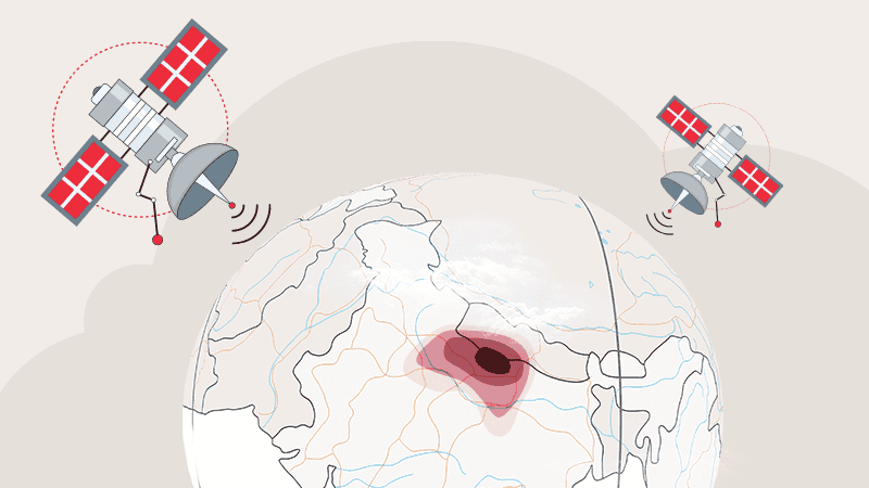
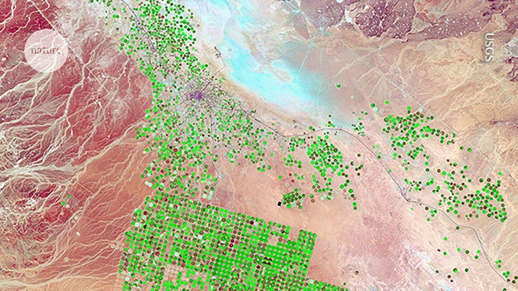
Google has come up with a way to better map Earth's disasters, predict them, and be able to track which communities and ecosystems are going to be wrought by their destruction. If you want to find out what's straining the environment in your neck of the woods, all you have to do is ask. Google Earth AI, a fusion of Google's Earth and Gemini AI systems, was introduced in July. Part of that effort is an AI model called AlphaEarth Foundations, which turns terabytes of satellite data into useful data layers tracking the history of what happens across the surface of the planet. The combined system lets users parse historical landscape data that can reveal great shifts in the climate over the years. For example, users can look at rising water levels in flood zones, chart changes in surface temperatures across regions of the planet, or see the effects of clean air policies by studying changes in air pollution. Now, Google has revealed new capabilities coming to its Earth AI platform. Users can now interact with the AI model by asking it questions like you would with a chatbot. An example Google gave was asking Earth AI to "find algae blooms" to help monitor water supplies. The system will search satellite images and its troves of collected data to give a list of results.
[2]
Google's New Earth AI Doesn't Just Predict Storms. It Determines Who's in the Path
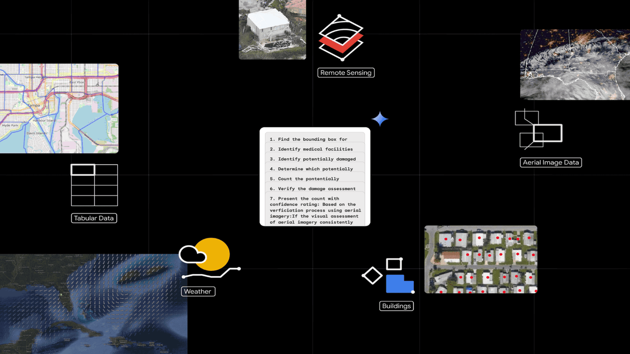
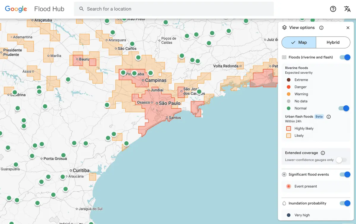
Macy has been working for CNET for coming on 2 years. Prior to CNET, Macy received a North Carolina College Media Association award in sports writing. When a hurricane forms or a river swells, the urgent question isn't just where the crisis will strike, but who will be hit the hardest. Google's latest update to Earth AI aims to answer both questions at once. The company said Thursday that it's expanding its geospatial technology, pairing its Gemini AI model with the vast store of weather, population and satellite data it has built over decades of mapping the planet. The result is a system that can connect the dots between physical events and human impact -- predicting not just the storm, but the communities most vulnerable to it. Read also: Google Earth Is 20, and the Digital Globe Has 2 Handy New Features for You Don't miss any of our unbiased tech content and lab-based reviews. Add CNET as a preferred Google source. At the heart of the update is a feature that Google Earth calls geospatial reasoning. It's essentially a connective layer that lets AI "think across" different types of Earth data -- weather forecasts, population maps, imagery -- to produce more complete answers. Instead of simply showing where a cyclone might make landfall, for example, this geospatial reasoning works to identify which neighborhoods are likely to flood, how many people live there and what infrastructure, such as power lines, might fail first. Google says that approach is already helping groups like GiveDirectly, which uses the system to pinpoint households most in need of cash aid after a flood. This is part of a broader trend within Google to use Gemini not just for chatting or coding, but to reason about the physical world. "To solve a complex problem, you need to see the whole picture," the company wrote in its press release, and geospatial reasoning is designed to do that. The new capabilities also reach into Google Earth, where users can now ask questions directly in natural language, typing phrases like "find algae blooms" or "show where rivers have dried up." Gemini scans satellite imagery to locate patterns that would once have required teams of analysts and custom GIS (geographic information system) scripts. A city official, for instance, could pull up flood forecasts, cross-reference them with population data, and quickly identify which hospitals or power lines are most at risk. What used to take days or weeks of analysis could now happen in minutes. Read also: Stay Prepared for Natural Disasters by Packing a Go Bag For governments, nongovernmental organizations and companies with their own data, Google is also bringing its core Earth AI models -- covering imagery, population and environmental layers -- to Google Cloud. A select group of Trusted Testers can now blend those models with their proprietary datasets to track everything from vegetation encroaching on power lines to pollution near schools. Organizations, such as the World Health Organization's Africa office, are already utilizing the system to forecast cholera outbreaks in the Democratic Republic of Congo, while insurers and energy companies are testing it for damage prediction and outage prevention. These updates build on Google's existing crisis tools, including flood forecasting that already covers more than 2 billion people. During the 2025 wildfires in California, Google's alerts reached 15 million residents. But with Gemini now woven into Google Earth AI, the company is trying to move from reactive alerts to proactive prevention, helping responders anticipate what's coming and who needs help first. For now, most of these features are limited to early testers, but Google says it plans to expand access in the coming months. If it works as promised, Earth AI could make global disaster response less about scrambling to catch up and more about staying one step ahead of the storm or natural disaster.
[3]
Google Earth AI wants to help us spot weather disasters and climate issues before they happen
Access to Google Earth AI has also been expanded to help solve issues Google has revealed a host of updates to Google Earth AI as it looks to help organizations, cities, and nonprofits alike react and respond to issues quicker and more effectively than ever before. This includes new geospatial reasoning tools, which can now connect different Earth AI models to answer complex questions, and other Gemini-powered AI tools to answer climate questions quickly. For example, the feature could bring together data on weather forecasts, population maps, and satellite imagery to spot potential dangers connected to where a storm will make landfall, and issues connected to subsequent flooding. "Earth AI is built on decades modeling the world, combined with state of the art predictive models and Gemini's advanced reasoning, letting enterprises, cities and nonprofits achieve deeper understanding in minutes -- efforts that previously required complex analytics and years of research," noted Chris Phillips, VP & GM, Geo, and Yossi Matias, VP & GM, Google Research in a blog post announcing the news. Initially launched in July 2025, Google Earth AI has already proved incredibly helpful, providing crisis alerts with information from local authorities to 15 million people following the 2025 California wildfires, helping them find shelter. The new upgrades will also include boosted Gemini AI capabilities, allowing analysts and other users to quickly find out information by asking questions of the model. This could allow a water company to identify where a river has recently dried up, meaning local communities can be notified of the risk of dust storms, or spot where harmful algae is blooming in order to monitor drinking water supply, giving authorities time to issue warnings or shut down water utilities. Interested organizations can sign up now to become "Trusted Testers" on Google Cloud, giving them direct access to the new Earth AI Imagery, Population, and Environment models and their related tools. Businesses can also use their own data alongside Google's own models and datasets, allowing them to tackle specific challenges such as environmental monitoring and disaster response.
[4]
New updates and more access to Google Earth AI
When disasters strike, Google products like Search and Maps help billions of people make critical decisions to stay safe. Our flood forecasting information -- now covering more than two billion people -- provides life-saving forecasts before the most significant river floods. It's helped organizations like World Vision get drinking water and food to communities when they need it most. And during the devastating 2025 California wildfires, we provided crisis alerts with information from local authorities to 15 million people across Los Angeles while showing them where to find shelter in Google Maps. This is all made possible by our geospatial AI models, not only for floods and wildfires, but cyclones, air quality and many more. We recently introduced Google Earth AI, bringing together these geospatial models to help tackle the planet's most critical needs. Earth AI is built on decades modeling the world, combined with state of the art predictive models and Gemini's advanced reasoning, letting enterprises, cities and nonprofits achieve deeper understanding in minutes -- efforts that previously required complex analytics and years of research. Today, we're advancing Earth AI's innovations and capabilities, and expanding access around the globe. Here's how: To solve a complex problem, you need to see the whole picture, not just one piece of it. That's the idea behind Geospatial Reasoning, a framework powered by Gemini that now lets AI automatically connect different Earth AI models -- like weather forecasts, population maps and satellite imagery -- to answer complex questions. Instead of just seeing where a storm might hit, our latest research demonstrates that analysts can use Geospatial Reasoning to identify which communities are most vulnerable and what infrastructure is at risk, all at once. For example, Geospatial Reasoning empowers the nonprofit GiveDirectly to respond to disasters by combining flood and population density information, helping them identify who needs direct aid most. Sign up for consideration to become a Trusted Tester for Geospatial Reasoning. Social impact organizations can learn about future support for nonprofits through Google.org and our non-commercial access programs.
[5]
Google Adds Geospatial Reasoning with Gemini on Earth AI Models | AIM
The AI model now combines decades of geospatial modelling with Gemini's advanced reasoning. Google has upgraded Earth AI, integrating Geospatial Reasoning powered by its Gemini models to help organisations better understand and respond to environmental and disaster challenges. This upgrade builds on decades of geospatial modelling. It enables AI to automatically connect multiple datasets including satellite imagery, weather forecasts, population maps, and environmental data to deliver a more comprehensive understanding of risks and vulnerabilities. By linking these datasets, Earth AI can provide actionable insights that previously required complex analytics and years of research. The system is already aiding real-world efforts: during the 2025 California wildfires, Google Maps deployed AI-driven crisis alerts, helping guide 15 million people to safety. Nonprofits like GiveDirectly use Earth AI to identify the communities most vulnerable to floods, enabling targeted and timely aid delivery. The upgrade also enhances Google Earth's capabilities. With Gemini-powered features, users can quickly detect changes in rivers, monitor harmful algae blooms, track deforestation, and assess environmental risks in near real time. These tools allow analysts to spot patterns and potential hazards that could affect public health, water supply, or local ecosystems. These features will initially roll out to US-based Google Earth Professional and Google AI Pro subscribers. Additionally, Earth AI models are now accessible via Google Cloud for Trusted Testers, allowing organisations to combine their own data with Earth AI's Population, Environment, and Imagery models. Current pilots include WHO Africa tracking cholera outbreaks, satellite companies analysing deforestation trends, and Alphabet's X-backed Bellwether improving hurricane prediction models for insurers.
[6]
The Future of Geospatial Data : Google Earth AI in Action
What if the vast, intricate web of planetary data could be transformed into insights that save lives, protect ecosystems, and shape the cities of tomorrow, all in real time? For decades, analyzing geospatial data has been a labor-intensive process, requiring immense resources and time. But now, with the advent of Google Earth AI, this paradigm is shifting. By harnessing the power of artificial intelligence, Google Earth AI is transforming how we interpret our planet, turning complex datasets into actionable intelligence that drives smarter, faster decisions. From predicting natural disasters to optimizing urban development, this technology is not just about observing the Earth, it's about empowering us to act on it. In this exploration of Google Earth AI, you'll discover how this new platform is automating geospatial analysis, delivering predictive insights, and allowing real-time decision-making across industries. Whether it's mapping flood-prone areas in hours instead of months or identifying health vulnerabilities with pinpoint accuracy, the possibilities are as vast as the datasets it processes. By the end, you'll see how this innovation is not just a tool for understanding the world but a fantastic option for building a more sustainable and resilient future. How might this technology change the way we respond to the challenges of our time? Let's unpack its fantastic potential. Traditional geospatial analysis has historically been a time-consuming and resource-intensive process. Google Earth AI addresses these challenges by automating complex tasks, integrating high-resolution data with predictive analytics to deliver insights in real time. This shift from manual to automated analysis is transforming industries, making it easier to derive actionable insights from geospatial data. By streamlining workflows, Google Earth AI enables organizations to allocate resources more effectively and respond to challenges with agility. One of the most impactful applications of Google Earth AI lies in its ability to predict and respond to natural disasters. By combining historical data with real-time updates, the platform offers precise forecasts for events such as floods, hurricanes, and droughts. This predictive capability allows you to act before disasters occur, minimizing risks and improving outcomes. By providing timely and accurate insights, the platform enhances disaster preparedness and resilience on a global scale. Here is a selection of other guides from our extensive library of content you may find of interest on Google AI. Google Earth AI is also transforming public health by integrating geospatial data with health statistics to identify and address vulnerabilities. This approach enables targeted interventions that improve health outcomes and resource allocation. By offering a data-driven approach to public health, Google Earth AI supports more efficient and effective interventions. This capability is particularly valuable in addressing global health challenges, where timely and accurate information is critical. Real-time data processing is a cornerstone of Google Earth AI's functionality, making sure that users have access to the most current information. This capability is especially valuable in dynamic scenarios where conditions change rapidly. By reducing the lag between data collection and decision-making, Google Earth AI enables you to respond to challenges as they arise. This real-time capability enhances situational awareness and supports more effective planning and execution. Google Earth AI's ability to handle diverse, high-resolution datasets makes it a versatile tool for addressing multi-dimensional challenges. Whether you are managing urban development, monitoring agricultural productivity, or planning infrastructure projects, the platform delivers tailored insights to meet your needs. By synthesizing diverse datasets, Google Earth AI provides the clarity needed to address intricate problems effectively. Its adaptability makes it an invaluable resource for organizations seeking to navigate the complexities of modern challenges. The ultimate goal of Google Earth AI is to support the creation of a more sustainable and resilient future. By delivering actionable intelligence, the platform enables proactive decision-making and long-term planning. This forward-looking approach enables you to address today's challenges while preparing for tomorrow's uncertainties. By integrating advanced analytics with real-time data, Google Earth AI provides the tools needed to build a future that is both resilient and sustainable.
Share
Share
Copy Link
Google has unveiled significant updates to its Earth AI platform, integrating Gemini AI for advanced geospatial reasoning. This enhancement aims to predict and mitigate climate disasters by connecting various data sources for comprehensive analysis.
Google Earth AI's Leap Forward with Gemini Integration
Google has announced a significant upgrade to its Earth AI platform, integrating Gemini AI to enhance its geospatial reasoning capabilities. This advancement marks a new era in predicting and responding to climate crises and natural disasters
1
4
.
Source: AIM
Enhanced Geospatial Reasoning
The core of this update is the new geospatial reasoning framework, powered by Gemini. This system can now automatically connect different Earth AI models, including weather forecasts, population maps, and satellite imagery, to provide comprehensive answers to complex questions
2
5
.For instance, instead of merely predicting where a storm might hit, the system can now identify which communities are most vulnerable and what infrastructure is at risk. This holistic approach allows for more targeted and effective disaster response
4
.
Source: Google
Natural Language Interaction
Google Earth AI now features a chatbot-like interface, allowing users to interact with the system using natural language queries. Analysts can ask questions like "find algae blooms" or "show where rivers have dried up," and the AI will scan satellite imagery to locate relevant patterns
1
3
.
Source: Wired
Related Stories

Real-World Applications
The system is already proving its worth in various real-world scenarios:
-
During the 2025 California wildfires, Google Maps deployed AI-driven crisis alerts, helping guide 15 million people to safety
4
5
. -
GiveDirectly, a nonprofit organization, uses Earth AI to identify communities most vulnerable to floods, enabling targeted and timely aid delivery
4
. -
The World Health Organization's Africa office is utilizing the system to forecast cholera outbreaks in the Democratic Republic of Congo
2
.
Expanded Access and Future Developments
Google is expanding access to Earth AI models through Google Cloud for Trusted Testers. This allows organizations to combine their own data with Earth AI's Population, Environment, and Imagery models
3
5
.Current pilots include satellite companies analyzing deforestation trends and Alphabet's X-backed Bellwether improving hurricane prediction models for insurers
5
.As Google continues to refine and expand Earth AI's capabilities, it aims to move from reactive alerts to proactive prevention, helping responders anticipate crises and prioritize aid efforts more effectively
2
.References
Summarized by
Navi
[3]
Related Stories
Google Unveils Geospatial Reasoning: A Revolutionary AI Approach to Analyzing Earth Data
09 Apr 2025•Technology
Google's AlphaEarth Foundations: AI Model Maps Earth in Unprecedented Detail
31 Jul 2025•Technology
Google uses Gemini AI and 5 million old news reports to predict flash floods across 150 countries
12 Mar 2026•Technology
Recent Highlights
1
AI Models Lie and Deceive to Protect Other AI Models From Deletion, Study Reveals
Science and Research

2
AI chatbots validate you too much, making you less kind to others, Stanford study reveals
Science and Research
3
Judge blocks Pentagon from blacklisting Anthropic over AI safety guardrails dispute
Policy and Regulation

Recent Highlights
Today's Top Stories


Your Daily Dose of Curated AI News
Don’t drown in AI news. We cut through the noise - filtering, ranking and summarizing the most important AI news, breakthroughs and research daily. Spend less time searching for the latest in AI and get straight to action.