Google's AlphaEarth Foundations: AI Model Maps Earth in Unprecedented Detail
14 Sources
14 Sources
[1]
Google AI model mines trillions of images to create maps of Earth 'at any place and time'
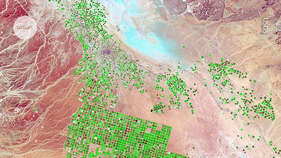
The technology giant Google has released an artificial intelligence (AI) model that acts as a 'virtual satellite' to weave together trillions of disparate observations -- satellite images, radar and more -- to track changes in land and shallow waters across Earth. Researchers are lauding the sheer scale of the effort while also calling on Google for more information about its tests, and warning that it will be up to individual scientists to verify any maps they obtain from the tool. The model, called AlphaEarth Foundations, maps the world "at any place and time", Christopher Brown, a research engineer at Google DeepMind in New York City, said at a press briefing on 28 July. Scientists might use it to identify the best places for clean-energy projects, study the ecological impacts of climate change, track deforestation and more. Alongside the model, which was released yesterday, Google and its DeepMind AI unit have posted a paper, ahead of peer review, to the arXiv preprint server. The manuscript describes the creation of the model, its initial testing and baseline data sets covering Earth during the years 2017-24. It says that AlphaEarth beats similar AI models in terms of both accuracy and data density, and that the model saves users computing time and reduces energy use. Nicholas Murray, a conservation biologist at James Cook University in Townsville, Australia, is the lead scientist for Global Ecosystems Atlas, an initiative to map the world's biodiversity and environments. Murray says that his team often spends "tens to hundreds of days" processing satellite data before it can even begin to make products such as maps describing changes in tidal wetlands over time. He hopes that Google's latest model -- which the team is familiar with -- will make that process more efficient. Moving forward, Google says, it will regularly update AlphaEarth's data sets, which come fully processed. They are available through the company's Earth Engine, a cloud-based platform that already hosts separate repositories of data covering topics such as agriculture, deforestation and weather. AlphaEarth weaves together many of these data sets to create an integrated product that scientists can explore more easily. Satellites view the world in terms of individual attributes such as colours and clouds. AlphaEarth processes those and other data into digital representations called 'embeddings', which can be easily searched for features such as tree species, buildings and groundwater, Brown said. The data are packaged in 10-metre squares covering land surfaces and coastal regions across Earth. "This allows AlphaEarth Foundations to provide a more complete, consistent and highly detailed picture of our planet's evolution," Brown added. "The scale is unprecedented, for sure, and I give the team enormous credit for pulling this off," says Solomon Hsiang, who studies global environmental policy at Stanford University in California and co-founded a competing AI model known as MOSAIKS. At the same time, Hsiang says, it's not entirely clear from the available data how to assess the model's performance and compare it with others in this space. He urges Google to release not just the processed information but also the actual data from its testing, so that other researchers can gain a better understanding of them "and build on what they have accomplished". Ultimately, the onus will be on individual researchers to assess the accuracy of the data and any limitations as they probe particular attributes of Earth, Murray says. Google says it has already provided the information that scientists need to assess the model and its performance.
[2]
Google's Newest AI Model Acts like a Satellite to Track Climate Change
AlphaEarth Foundations is a chip off Google DeepMind block -- and it's here to help save the world. Google's newest AI model is going to scour the Earth and, ideally, help it out. That's the plan, anyway. The mission is to find out once and for all, in fine detail, what we are doing to our planet. Crucially, once the model has supposedly done this it will also, apparently, explain where we might be able to best put things in place to help our world. AlphaEarth Foundations, an offshoot of Google's DeepMind AI model, aims to leverage machine learning and all the gobs and gobs of data that Google has absorbed about our planet over the last two decades, in order to understand how specific areas are changing over time. The model uses a system called "embeddings" that takes terabytes of data collected from satellites every day, analyzes it, and compresses it down to save storage space. The result is a model of different filters overlaid over maps that are color coded to indicate material properties, vegetation types, groundwater sources, and human constructions such as buildings and farms. Google says the system will act as a sort of "virtual satellite," letting users call up on demand detailed information about any given spot on the planet. The goal, Google says, is for users of the service to be able to better understand how specific ecosystems on the planet work, including how air quality, sunlight, groundwater, and even human construction projects vary and change across a landscape. Ultimately, the company wants the model to help answer questions from paying governments and corporations that wish to know, for example, which ecosystems may have more access to sunlight or groundwater that can help determine the best spots to grow a certain crop. Alternatively, it may aid in identifying areas to plop down solar panels with maximum payoff, or build structures in more climate resilient locations. Google's new model has already mapped a complex surface in Antarctica -- an area notoriously difficult to capture due to irregular satellite imaging -- in clear detail. It has also supposedly outlined variations in Canadian agricultural land use that are invisible to the naked eye.
[3]
Google AI Model Helps Us See the Planet as We Never Have Before
Alex Valdes from Bellevue, Washington has been pumping content into the Internet river for quite a while, including stints at MSNBC.com, MSN, Bing, MoneyTalksNews, Tipico and more. He admits to being somewhat fascinated by the Cambridge coffee webcam back in the Roaring '90s. It's a view of Mother Earth as we've never seen her, and it just might help us solve some our most existential issues: Google has launched a new AI model called AlphaEarth Foundations, which can take a bunch of images and measurements from satellites and other sources to create current and accurate digital representations of lands and waters. With all this data, scientists and researchers can monitor problems like water scarcity, deforestation and crop health, among others. Google says AlphaEarth's AI modeling has already been helpful. "Our partners are already seeing significant benefits, using the data to better classify unmapped ecosystems, understand agricultural and environmental changes, and greatly increase the accuracy and speed of their mapping work," the Google DeepMind blog said Wednesday. Satellites deliver a treasure trove of data every day, but all this information varies in its modalities -- such as satellite, radar, simulations and laser mapping -- and how current it is. AlphaEarth can integrate all that data and "weaves all this information together to analyze the world's land and coastal waters in sharp, 10x10 meter squares." AlphaEarth also creates summaries for each of these squares that "require 16 times less storage space than those produced by other AI systems that we tested and dramatically reduces the cost of planetary-scale analysis," Google said. Scientists "no longer have to rely on a single satellite passing overhead."
[4]
Google calls its new AI model a "virtual satellite.
Called AlphaEarth Foundations, the model stitches together data from actual satellite images, radar, climate simulations, and more to map Earth's land and coastal waters. "The Satellite Embedding dataset is revolutionizing our work by helping countries map uncharted ecosystems - this is crucial for pinpointing where to focus their conservation efforts," Nick Murray, director of the James Cook University Global Ecology Lab and Global Science Lead of Global Ecosystems Atlas, said in a Google DeepMind blog post.
[5]
Google AI model maps world in 10-meter squares for machines
DeepMind geospatial AI model offers comprehensive view of Earth image data Google has released a new AI model that maps the world in 10-meter squares for machines to read. The company's AlphaEarth Foundations model has been trained on vast amounts of Earth observation data from satellites and other sources to produce embeddings for computer programs, rather than visual imagery or some other form of output intended for human interpretation. AlphaEarth Foundations, according to Google DeepMind researchers, "accurately and efficiently characterizes the planet's entire terrestrial land and coastal waters by integrating huge amounts of Earth observation data into a unified digital representation, or 'embedding,' that computer systems can easily process." The model thus is able to provide scientists with a comprehensive view of Earth over time, to help with research into environmental and agricultural concerns like deforestation and water resources drained by datacenters running AI models. Embeddings are vectors - numerical representations of data points - created by machine learning models that encode data about some object. They define how different objects within a model are related to each other. Vectors in math are modelled in dimensional space. A two-dimensional vector, for example, could be represented by two numbers, X and Y. AlphaEarth's embeddings have 64 dimensions, each representing a 10-meter pixel that encodes data from multiple sources about terrestrial surface conditions around that plot over the course of a year. AlphaEarth makes Earth observation information available as a data set of embeddings so that it can be processed efficiently by deep learning applications like Google Earth Engine. According to its creators, the model's succinct data summaries for its 10-meter squares allow it to operate with 16x less storage space and lower cost than other AI systems. The model is also said to be more accurate, with an error rate 24 percent lower than other models. Google DeepMind researchers say AlphaEarth improves upon prior geospatial foundation models like SatMAE (Cong et al., 2022) and SatCLIP (Klemmer et al., 2025) by averaging the embeddings across multiple sources, by including time into the modeling framework, and by offering spatial resolution at high precision. With the announcement of AlphaEarth, Google is releasing its Satellite Embedding dataset, produced by the model, for use in applications like Earth Engine. Google research scientist Valerie Pasquarella and product manager Emily Schechter suggest the dataset can be used for conducting a similarity search (identifying areas similar to other areas based on specified criteria), detecting geographical change, discovering hidden patterns, and creating maps without manual labeling. Christopher Seeger, professor and extension specialist of landscape architecture and geospatial technology at Iowa State University, told The Register in a phone interview that he expects AlphaEarth Foundations will be quite beneficial. "Dealing with discrete data sets alone can be challenging, but when you bring in multiple disparate data sets and are trying to do the analysis it can be an intensive use of the machine," he said. "And even at best, you can usually only do small areas of what you're studying." Leaning on AI to look at features across multiple data sets, he said, looks like an interesting use of the technology. "I'm happy to see that they are doing some ground truthing with this to find out how reliable the models are, of course. And so I look forward to seeing what's possible with this, not just at a global scale, but at a more regional scale." Seeger said the application of AI to this sort of data makes a lot of sense. "What is interesting is that they're able to get down to 10 by 10 meter squares, which is phenomenal," he said. "It's going to be great for decision makers." ®
[6]
Google's 'virtual satellite' AI model can provide a near real-time view of Earth
It can help researchers track changes to our planet over time. Google has introduced a new AI model called AlphaEarth Foundations that it says can function like a "virtual satellite." The model uses a system called "embedding," which works by taking big volumes of pubic information from various sources every day, such as optical satellites, radars and climate simulations, and then combining them all together. It then divides lands and coastal waters into 10x10 meter squares, which it then analyzes and tracks over time. As Wired explains, these squares are color-coded to indicate different characteristics, such as vegetation types and material properties. The company said AlphaEarth Foundations makes its data easy to use by creating what it calls "highly compact summary" for each square of land or coastal water it monitors. These compact summaries apparently need 16 times less storage compared to those produced by comparable AI systems, thereby reducing costs needed for Earth observation. So what exactly can the model's data be used for? Google explained that scientists can use the model to create detailed maps on demand for multiple purposes, such as to monitor crop health or to track deforestation. In its announcement, the company claimed that the model excelled at a wide range of tasks over different time periods when it was tested. "AlphaEarth Foundations represents a significant step forward in understanding the state and dynamics of our changing planet," Google wrote. The company gave over 50 organizations access to the model's Satellite Embedding dataset, a collection of its annual embeddings, to test its use in real world applications over the past year. Now, it has released the dataset in Google Earth Engine so that other scientists can use it for their own research.
[7]
A new Google Earth AI model aims to make satellites obsolete
I tried using Android without any Google apps. Here's how far I could go Google's new AlphaEarth Foundations AI isn't a satellite. It's a system designed to make satellites themselves a lot less indispensable. Instead of waiting for orbital flyovers and stitching together uneven, sometimes cloudy datasets, AlphaEarth Foundations builds a persistent, unified model of the Earth's surface and coastal waters. Think of it as a "virtual satellite" that can see more clearly, more consistently, and in some ways more accurately than traditional space-based sensors (Source: Google Deepmind). A fascinating use of AI This is way more than your grandpa's Google Earth The color-coded, information-dense imaging representing Alphaearth Foundations' advanced mapping. At its core, AlphaEarth Foundations integrates petabytes of Earth observation data -- from radar and optical satellites to 3D lidar mapping and climate models -- into what Google calls a global embedding. This embedding condenses massive datasets into uniform, easy-to-use summaries that describe the planet in 10-by-10-meter squares. The end result is a digital Earth twin that's compact enough to analyze at scale, but rich enough to track changes in land use, vegetation health, and even coastal dynamics. Where satellites stumble, AlphaEarth Foundations steps in. The team behind the model showed off examples in Ecuador, where persistent cloud cover has historically made agricultural monitoring nearly impossible. AlphaEarth was able to cut through the noise, mapping farmland in different stages of development without waiting for clear skies. In Antarctica, a nightmare scenario for most orbiting imagers due to irregular coverage and low light, the model rendered surface features in crisp detail. In Canada, it exposed subtle agricultural land-use changes invisible to conventional satellite imaging. Each embedding consists of 64 dimensions. Taken as a whole, they cover the entire globe. The model doesn't just produce prettier maps. Its technical efficiency matters just as much. According to Google, the embeddings require 16 times less storage than comparable AI systems, making them cheap to use at planetary scale. In head-to-head testing, AlphaEarth Foundations delivered a 24% lower error rate than other leading AI mapping models, even when label data was scarce. That kind of efficiency translates directly into faster, more accurate decision-making for scientists and policymakers. And the tech isn't locked behind a corporate wall. Google is releasing a massive set of AlphaEarth embeddings -- over 1.4 trillion footprints per year -- through the Google Earth Engine as the Satellite Embedding dataset. More than 50 organizations, including the United Nations Food and Agriculture Organization, Stanford University, and Brazil's MapBiomas project, have already put the system to work. Examples of how embeddings take into accout data from various sources and timeframes. The use cases are real and immediate. The Global Ecosystems Atlas is using the dataset to classify minimally or unmapped ecosystems such as hyper-arid deserts and coastal shrublands -- data critical for conservation planning. In Brazil, MapBiomas is leveraging the embeddings to monitor agricultural expansion and deforestation in the Amazon, generating faster and more precise insights than traditional methods. Nick Murray, Director of the Global Ecology Lab at James Cook University, called the dataset "revolutionary" for ecosystem mapping. MapBiomas founder Tasso Azevedo said it enables "maps that are more accurate, precise, and fast to produce, [which is] something we would have never been able to do before." Long term, AlphaEarth could be paired with reasoning LLMs like Google's Gemini to unlock even more advanced geospatial intelligence. For now, though, the system represents a seismic shift in Earth observation: a move from relying on the timing and limits of satellites to a constantly updated, AI-driven view of the planet. If AlphaEarth Foundations delivers on its early promise, the future of global monitoring may not orbit above us -- it may already be here.
[8]
AlphaEarth Foundations helps map our planet in unprecedented detail
New AI model integrates petabytes of Earth observation data to generate a unified data representation that revolutionizes global mapping and monitoring Every day, satellites capture information-rich images and measurements, providing scientists and experts with a nearly real-time view of our planet. While this data has been incredibly impactful, its complexity, multimodality and refresh rate creates a new challenge: connecting disparate datasets and making use of them all effectively. Today, we're introducing AlphaEarth Foundations, an artificial intelligence (AI) model that functions like a virtual satellite. It accurately and efficiently characterizes the planet's entire terrestrial land and coastal waters by integrating huge amounts of Earth observation data into a unified digital representation, or "embedding," that computer systems can easily process. This allows the model to provide scientists with a more complete and consistent picture of our planet's evolution, helping them make more informed decisions on critical issues like food security, deforestation, urban expansion, and water resources. To accelerate research and unlock use cases, we are now releasing a collection of AlphaEarth Foundations' annual embeddings as the Satellite Embedding dataset in Google Earth Engine. Over the past year, we've been working with more than 50 organizations to test this dataset on their real-world applications. Our partners are already seeing significant benefits, using the data to better classify unmapped ecosystems, understand agricultural and environmental changes, and greatly increase the accuracy and speed of their mapping work. In this blog, we are excited to highlight some of their feedback and showcase the tangible impact of this new technology.
[9]
Google DeepMind says its new AI can map the entire planet with unprecedented accuracy
Want smarter insights in your inbox? Sign up for our weekly newsletters to get only what matters to enterprise AI, data, and security leaders. Subscribe Now Google DeepMind announced today a breakthrough artificial intelligence system that transforms how organizations analyze Earth's surface, potentially revolutionizing environmental monitoring and resource management for governments, conservation groups, and businesses worldwide. The system, called AlphaEarth Foundations, addresses a critical challenge that has plagued Earth observation for decades: making sense of the overwhelming flood of satellite data streaming down from space. Every day, satellites capture terabytes of images and measurements, but connecting these disparate datasets into actionable intelligence has remained frustratingly difficult. "AlphaEarth Foundations functions like a virtual satellite," the research team writes in their paper. "It accurately and efficiently characterizes the planet's entire terrestrial land and coastal waters by integrating huge amounts of Earth observation data into a unified digital representation." The AI system reduces error rates by approximately 23.9% compared to existing approaches while requiring 16 times less storage space than other AI systems. This combination of accuracy and efficiency could dramatically lower the cost of planetary-scale environmental analysis. The core innovation lies in how AlphaEarth Foundations processes information. Rather than treating each satellite image as a separate piece of data, the system creates what researchers call "embedding fields" -- highly compressed digital summaries that capture the essential characteristics of Earth's surface in 10-meter squares. "The system's key innovation is its ability to create a highly compact summary for each square," the research team explains. "These summaries require 16 times less storage space than those produced by other AI systems that we tested and dramatically reduces the cost of planetary-scale analysis." This compression doesn't sacrifice detail. The system maintains what the researchers describe as "sharp, 10×10 meter" precision while tracking changes over time. For context, that resolution allows organizations to monitor individual city blocks, small agricultural fields, or patches of forest -- critical for applications ranging from urban planning to conservation. More than 50 organizations have been testing the system over the past year, with early results suggesting transformative potential across multiple sectors. In Brazil, MapBiomas uses the technology to understand agricultural and environmental changes across the country, including within the Amazon rainforest. "The Satellite Embedding dataset can transform the way our team works," Tasso Azevedo, founder of MapBiomas, said in a statement. "We now have new options to make maps that are more accurate, precise and fast to produce -- something we would have never been able to do before." The Global Ecosystems Atlas initiative employs the system to create what it calls the first comprehensive resource for mapping the world's ecosystems. The project helps countries classify unmapped regions into categories like coastal shrublands and hyper-arid deserts -- crucial information for conservation planning. "The Satellite Embedding dataset is revolutionizing our work by helping countries map uncharted ecosystems -- this is crucial for pinpointing where to focus their conservation efforts," said Nick Murray, Director of the James Cook University Global Ecology Lab and Global Science Lead of Global Ecosystems Atlas. The research paper reveals sophisticated engineering behind these capabilities. AlphaEarth Foundations processes data from multiple sources -- optical satellite images, radar, 3D laser mapping, climate simulations, and more -- weaving them together into a coherent picture of Earth's surface. What sets the system apart technically is its handling of time. "To the best of our knowledge, AEF is the first EO featurization approach to support continuous time," the researchers note. This means the system can create accurate maps for any specific date range, even interpolating between observations or extrapolating into periods with no direct satellite coverage. The model architecture, dubbed "Space Time Precision" or STP, simultaneously maintains highly localized representations while modeling long-distance relationships through time and space. This allows it to overcome common challenges like cloud cover that often obscures satellite imagery in tropical regions. For technical decision-makers in enterprise and government, AlphaEarth Foundations could fundamentally change how organizations approach geospatial intelligence. The system excels particularly in "sparse data regimes" -- situations where ground-truth information is limited. This addresses a fundamental challenge in Earth observation: while satellites provide global coverage, on-the-ground verification remains expensive and logistically challenging. "High-quality maps depend on high-quality labeled data, yet when working at global scales, a balance must be struck between measurement precision and spatial coverage," the research paper notes. AlphaEarth Foundations' ability to extrapolate accurately from limited ground observations could dramatically reduce the cost of creating detailed maps for large areas. The research demonstrates strong performance across diverse applications, from crop type classification to estimating evapotranspiration rates. In one particularly challenging test involving evapotranspiration -- the process by which water transfers from land to atmosphere -- AlphaEarth Foundations achieved an R² value of 0.58, while all other methods tested produced negative values, indicating they performed worse than simply guessing the average. The announcement places Google at the forefront of what the company calls "Google Earth AI" -- a collection of geospatial models designed to tackle planetary challenges. This includes weather predictions, flood forecasting, and wildfire detection systems that already power features used by millions in Google Search and Maps. "We've spent years building powerful AI models to solve real-world problems," write Yossi Matias, VP & GM of Google Research, and Chris Phillips, VP & GM of Geo, in an accompanying blog post published this morning. "These models already power features used by millions, like flood and wildfire alerts in Search and Maps; they also provide actionable insights through Google Earth, Google Maps Platform and Google Cloud Platform." The release includes the Satellite Embedding dataset, described as "one of the largest of its kind with over 1.4 trillion embedding footprints per year," available through Google Earth Engine. This dataset covers annual snapshots from 2017 through 2024, providing historical context for tracking environmental changes. Google emphasizes that the system operates at a resolution designed for environmental monitoring rather than individual tracking. "The dataset cannot capture individual objects, people, or faces, and is a representation of publicly available data sources, such as meteorological satellites," the company clarifies. The 10-meter resolution, while precise enough for most environmental applications, intentionally limits the ability to identify individual structures or activities -- a design choice that balances utility with privacy protection. The availability of AlphaEarth Foundations through Google Earth Engine could democratize access to sophisticated Earth observation capabilities. Previously, creating detailed maps of large areas required significant computational resources and expertise. Now, organizations can leverage pre-computed embeddings to generate custom maps rapidly. "This breakthrough enables scientists to do something that was impossible until now: create detailed, consistent maps of our world, on-demand," the research team writes. "Whether they are monitoring crop health, tracking deforestation, or observing new construction, they no longer have to rely on a single satellite passing overhead." For enterprises involved in supply chain monitoring, agricultural production, urban planning, or environmental compliance, the technology offers new possibilities for data-driven decision-making. The ability to track changes at 10-meter resolution globally, with annual updates, provides a foundation for applications ranging from verifying sustainable sourcing claims to optimizing agricultural yields. The Satellite Embedding dataset is available now through Google Earth Engine, with AlphaEarth Foundations continuing development as part of Google's broader Earth AI initiative. As one researcher noted during the press briefing, the question facing organizations isn't whether they need planetary-scale intelligence anymore -- it's whether they can afford to operate without it.
[10]
Google Earth AI: Our state-of-the-art geospatial AI models
Sorry, your browser doesn't support embedded videos, but don't worry, you can download it and watch it with your favorite video player! We've spent years building powerful AI models to solve real-world problems. Today we're introducing Google Earth AI, our collection of geospatial models and datasets to help people, businesses and organizations tackle the planet's most critical needs. AlphaEarth Foundations, also announced today, is part of Google Earth AI. Google Earth AI expands on our recent Geospatial Reasoning effort and includes models that address multiple areas. Notable examples include detailed weather predictions, flood forecasting and wildfire detection. Other models help improve urban planning and public health by providing a rich understanding of imagery, population dynamics and urban mobility. These models already power features used by millions, like flood and wildfire alerts in Search and Maps; they also provide actionable insights through Google Earth, Google Maps Platform and Google Cloud. As we continue this work, we're committed to giving people the information they need to solve some of the biggest challenges of our time.
[11]
Google DeepMind releases highly accurate AI model map of Earth - SiliconANGLE
Google DeepMind releases highly accurate AI model map of Earth Google DeepMind, Alphabet Inc.'s artificial intelligence research arm, announced the release of AlphaEarth Foundations on Wednesday, a new AI model that can process terabytes of daily satellite data to track changes on the Earth's surface. The new model is being launched as part of the company's Google Earth AI initiative, a collection of geospatial AI models and datasets that will provide help for researchers, businesses and organizations to tackle real-world problems facing the world today. Google described the new AI model as one that functions like a "virtual satellite," capable of accurately and efficiently mapping the entire land and coastal waters of the planet into a digital representation, called embeddings, which machine learning and AI algorithms can process. "This allows the model to provide scientists with a more complete and consistent picture of our planet's evolution, helping them make more informed decisions on critical issues like food security, deforestation, urban expansion, and water resources," the AlphaEarth team said. According to DeepMind, the model compiles vast volumes of information from dozens of public sources, including optical satellite images, radar, 3D laser mapping and climate simulation into 10×10 meter squares. This allows the model to track changes over time with high precision. It compresses information by generating summaries that occupy 16 times less storage than traditional AI systems, thus reducing the costs of planetary-scale analysis. In tests, DeepMind said AlphaEarth had a 24% lower error rate than other models the team tested it against. The company has already generated a powerful dataset for practical use in Google Earth Engine, the Satellite Embedding dataset, one of the largest of its kind, with over 1.4 trillion embedding footprints per year. DeepMind said the dataset is already in practical use by organizations around the world, including the United Nations' Food and Agriculture Organization, Harvard Forest, Group on Earth Observations, MapBiomas, Oregon State University, the Spatial Informatics Group and Stanford University. Google Earth Engine, launched 15 years ago, is Google's long-running multi-petabyte catalog of satellite imagery and geospatial datasets for planetary-scale analysis. "The Satellite Embedding dataset is revolutionizing our work by helping countries map uncharted ecosystems -- this is crucial for pinpointing where to focus their conservation efforts," said Nick Murray, director of the James Cook University Global Ecology Lab and global science lead of Global Ecosystems Atlas. The Global Ecosystems Atlas initiative aims to map and monitor the world's ecosystems using environmental data. It is using the new dataset to help countries and governments classify unmapped ecosystems into categories such as coastal shrublands and hyper-arid deserts. Using this resource, organizations can know how to direct their resources to help combat the loss of biodiversity and prioritize conservation areas. DeepMind said the model enables more scientists, researchers and governments to do something that wasn't possible before: generate consistent, detailed maps of the world on demand without the need for satellites. With annualized tracking data researchers can be easily make long-term comparisons across both regions and time. Including how Atlas is using the system, scientists can use the model to monitor crop health, track deforestation or observe new construction to track urban sprawl. Since the data is mapped in a rich manner, it can be searched, compared and combined with deep AI reasoning to create powerful planetary mapping information systems.
[12]
DeepMind unveils AlphaEarth to map planet in 10-meter detail
Google DeepMind has announced a new artificial intelligence system, AlphaEarth Foundations, designed to analyze the Earth's surface by integrating vast amounts of observation data into a unified digital model. The system processes information from multiple sources, including optical satellite images, radar, 3D laser mapping, and climate simulations. The core technology creates highly compressed digital summaries, or "embedding fields," for 10×10 meter squares of the planet's terrestrial land and coastal waters. According to the research paper, this approach reduces error rates by approximately 23.9% compared to existing methods while requiring 16 times less storage space than other tested AI systems. A key technical feature is its support for "continuous time," allowing it to generate accurate maps for specific date ranges by interpolating data to fill gaps caused by factors like cloud cover. For the past year, over 50 organizations have been testing the system. In Brazil, the organization MapBiomas is using the technology to monitor agricultural and environmental changes, including deforestation in the Amazon. The Global Ecosystems Atlas initiative is also using it to create a comprehensive resource for mapping the world's ecosystems to aid conservation efforts. The system's "Satellite Embedding dataset," which contains over 1.4 trillion data footprints per year, is now available through Google Earth Engine. This dataset includes annual snapshots from 2017 through 2024. Google states that the 10-meter resolution is designed for environmental monitoring and cannot capture or identify individual people, faces, or objects.
[13]
The AI That Can Predict Environmental Disasters Before They Strike
AlphaEarth, created by DeepMind, is not some other AI test. It's a planetary-scale monitoring system driven by machine learning - to observe, study, and forecast Earth's dynamic surface in near real-time. Imagine a "virtual satellite" that never closes its eyes. Conventional satellite systems capture enormous amounts of imagery, but deciphering the information takes time and is often arcane. AlphaEarth breaks through the static. It doesn't merely look; it interprets. It can recognize patterns in environmental data that human eyes might overlook, and do so over huge geographic expanses, quickly. One of AlphaEarth's most important abilities is the detection of change. Whether deforestation in the Amazon, glacier melting in the Arctic, or urban growth in Africa, the AI catches subtle movements early on. That provides researchers, governments, and NGOs with a lead time to react to urgent changes. In farming, AlphaEarth provides precision information. It is capable of monitoring soil moisture, crop well-being, and water supply, enabling farmers to make improved decisions regarding planting, irrigation, and reaping. That's important as climate uncertainty rises and food security becomes more vulnerable. For disaster management, the model can be used to evaluate flood hazards, landslides, or wildfire propagation. Modeling terrain and weather information, it can predict probable effects of natural phenomena, giving vital advance notice to communities and responders. The AI's predictive power comes from its training. AlphaEarth was fed enormous volumes of satellite images, climate models, topography maps, and historical data. It learned to correlate visual changes with environmental outcomes, making it far more than just an image classifier. But most significant of all: it doesn't require new satellites to function. AlphaEarth takes advantage of current Earth observation data and makes it intelligent. It converts raw images into real-world knowledge - at speed, scale, and accuracy no human team could achieve. Privacy is minimal. The system is interested in natural and environmental information, not residential or personal areas. Its purpose is ecological, not surveillance-related. The larger vision? AlphaEarth can be a foundation for worldwide environmental insight. As governments and institutions compete to achieve sustainability targets, they'll require instruments that look beyond borders and slice through complexity. That's precisely what AlphaEarth provides. In a world with climate pandemonium, dwindling biodiversity, and exploding cities, AlphaEarth provides us with a clearer, speedier picture of what's occurring, and what's on the horizon. It's not just a map. It's a portal to Earth's future.
[14]
New Google AI model monitors changes on Earth from orbit - VnExpress International
Google is rolling out AlphaEarth Foundations, a new AI model designed to track in detail changes occurring on Earth. The system will identify how human activity is shaping the planet, and suggest solutions to mitigate environmental damage, according to U.S. magazine Wired. AlphaEarth Foundations processes vast amounts of satellite data that Google has collected over the past two decades. Using a system called "embeddings," it condenses terabytes of daily satellite imagery into compact, color-coded maps. These maps reveal material properties, vegetation types, groundwater reserves, and human-made structures such as farms and buildings. The model is intended to give governments and businesses precise environmental intelligence. This ranges from locating the most suitable areas for crops or solar farms to identifying climate-resilient sites for construction. It can also help map ecosystems by tracking variables such as air quality, sunlight exposure and groundwater availability. Google says the AI has already produced detailed maps of Antarctica's surface, where irregular satellite coverage has made monitoring difficult. It has also detected subtle changes in Canadian farmlands that are invisible to the naked eye. Chris Brown, a research engineer at Google DeepMind, says the biggest challenges in making reliable planetary data accessible are information overload and inconsistency. "Before, the challenge was getting a look at it all. Now, the challenge is to unify all the ways that we have to observe and model our planet and get a complete picture."
Share
Share
Copy Link
Google has released AlphaEarth Foundations, an AI model that integrates vast amounts of Earth observation data to create detailed, up-to-date maps of the planet's land and coastal waters.
Google Introduces AlphaEarth Foundations
Google, in collaboration with its DeepMind AI unit, has unveiled a groundbreaking artificial intelligence model called AlphaEarth Foundations. This innovative technology acts as a 'virtual satellite,' weaving together trillions of disparate observations from satellite images, radar, and other sources to track changes in land and shallow waters across Earth
1
.
Source: CNET
Unprecedented Scale and Efficiency
AlphaEarth Foundations maps the world "at any place and time" in remarkable detail, processing data into 10-meter squares covering land surfaces and coastal regions
1
. The model uses a system called "embeddings" to analyze and compress terabytes of daily satellite data, resulting in color-coded maps that indicate material properties, vegetation types, groundwater sources, and human constructions2
.What sets AlphaEarth apart is its efficiency. The model's data summaries require 16 times less storage space than those produced by other AI systems, dramatically reducing the cost of planetary-scale analysis
3
. This efficiency is achieved through 64-dimensional embeddings, each representing a 10-meter pixel that encodes data from multiple sources about terrestrial surface conditions over the course of a year5
.Applications and Potential Impact
Scientists and researchers can use AlphaEarth for a wide range of applications, including:
- Identifying optimal locations for clean-energy projects
- Studying ecological impacts of climate change
- Tracking deforestation
- Monitoring water scarcity and crop health
- Classifying unmapped ecosystems
1
3
Nicholas Murray, director of the James Cook University Global Ecology Lab, highlighted the model's potential: "The Satellite Embedding dataset is revolutionizing our work by helping countries map uncharted ecosystems - this is crucial for pinpointing where to focus their conservation efforts"
4
.
Source: Nature
Technical Advancements and Comparisons
AlphaEarth Foundations improves upon prior geospatial foundation models like SatMAE and SatCLIP by averaging embeddings across multiple sources, incorporating time into the modeling framework, and offering high-precision spatial resolution
5
. Google claims that the model outperforms similar AI models in terms of both accuracy and data density, with an error rate 24 percent lower than other models1
5
.Related Stories

Accessibility and Future Updates
Google has made AlphaEarth's data sets available through its Earth Engine, a cloud-based platform that hosts separate repositories of data covering topics such as agriculture, deforestation, and weather
1
. The company plans to regularly update these data sets, which come fully processed and ready for exploration by scientists.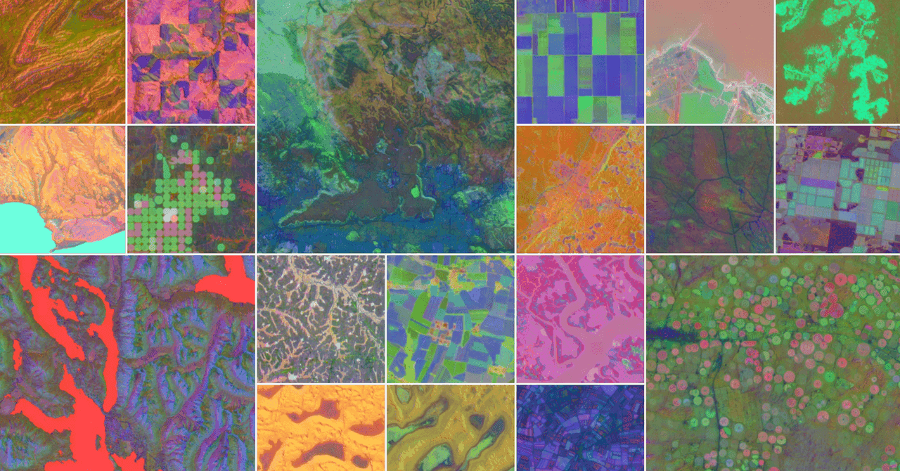
Source: Wired
Cautionary Notes and Verification
While the scientific community has lauded the scale and potential of AlphaEarth Foundations, some researchers are calling for more information about Google's testing procedures. Solomon Hsiang, who co-founded a competing AI model, urges Google to release not just the processed information but also the actual data from its testing
1
.Ultimately, the responsibility will fall on individual researchers to assess the accuracy of the data and any limitations as they probe particular attributes of Earth. As the technology continues to evolve, it promises to provide unprecedented insights into our planet's changing landscape, potentially revolutionizing environmental research and conservation efforts.
References
Summarized by
Navi
[4]
[5]
Related Stories
Google Earth AI Evolves: Gemini-Powered Geospatial Reasoning Tackles Climate Crises
23 Oct 2025•Technology
Google Unveils AI-Powered Environmental Conservation Platform to Support Global 30x30 Initiative
06 Nov 2025•Technology

Google Unveils Geospatial Reasoning: A Revolutionary AI Approach to Analyzing Earth Data
09 Apr 2025•Technology
Recent Highlights
1
OpenAI Releases GPT-5.4, New AI Model Built for Agents and Professional Work
Technology

2
Anthropic sues Pentagon over supply chain risk label after refusing autonomous weapons use
Policy and Regulation

3
OpenAI secures $110 billion funding round as questions swirl around AI bubble and profitability
Business and Economy

Recent Highlights
Today's Top Stories

Your Daily Dose of Curated AI News
Don’t drown in AI news. We cut through the noise - filtering, ranking and summarizing the most important AI news, breakthroughs and research daily. Spend less time searching for the latest in AI and get straight to action.