Google uses Gemini AI and 5 million old news reports to predict flash floods across 150 countries
6 Sources
6 Sources
[1]
Google is using old news reports and AI to predict flash floods
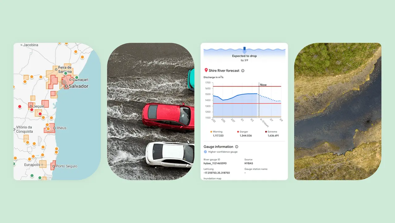
Flash floods are among the deadliest weather events in the world, killing more than 5,000 people each year. They're also among the most difficult to predict. But Google thinks it has cracked that problem in an unlikely way -- by reading the news. While humans have assembled a lot of weather data, flash floods are too short-lived and localized to be measured comprehensively, the way the temperature or even river flows are monitored over time. That data gap means that deep learning models, which are increasingly capable of forecasting the weather, aren't able to predict flash floods. To solve that problem, Google researchers used Gemini -- Google's large language model -- to sort through 5 million news articles from around the world, isolating reports of 2.6 million different floods, and turning those reports into a geo-tagged time series dubbed "Groundsource." It's the first time that the company has used language models for this kind of work, according to Gila Loike, a Google Research product manager. The research and data set was shared publicly Thursday morning. With Groundsource as a real-world baseline, the researchers trained a model built on a Long Short-Term Memory (LSTM) neural network to ingest weather global forecasts and generate the probability of flash floods in a given area. Google's flash flood forecasting model is now highlighting risks for urban areas in 150 countries on the company's Flood Hub platform, and sharing its data with emergency response agencies around the world. António José Beleza, an emergency response official at the Southern African Development Community who trialed the forecasting model with Google, said it helped his organization respond to floods more quickly. There are still limitations to the model. For one, it is fairly low resolution, identifying risk across 20-square-kilometer areas. And it is not as precise as the US National Weather Service's flood alert system, in part because Google's model doesn't incorporate local radar data, which enables real-time tracking of precipitation. Part of the point, though, is that the project was designed to work in places where local governments can't afford to invest in expensive weather-sensing infrastructure or don't have extensive records of meteorological data. "Because we're aggregating millions of reports, the Groundsource data set actually helps rebalance the map," Juliet Rothenberg, a program manager on Google's Resilience team, told reporters this week. "It enables us to extrapolate to other regions where there isn't as much information." Rothenberg said the team hopes that using LLMs to develop quantitative data sets from written, qualitative sources could be applied to efforts to building data sets about other ephemeral-but-important-to-forecast phenomena, like heat waves and mud slides. Marshall Moutenot, the CEO of Upstream Tech, a company that uses similar deep learning models to forecast river flows for customers like hydropower companies, said Google's contribution is part of a growing effort to assemble data for deep learning-based weather forecasting models. Moutenot co-founded dynamical.org, a group curating a collection of machine learning-ready weather data for researchers and startups. "Data scarcity is one of the most difficult challenges in geophysics," Moutenot said. "Simultaneously, there's too much Earth data, and then when you want to evaluate against truth, there's not enough. This was a really creative approach to get that data."
[2]
Google Is Using AI, Historic News Coverage to Predict Flash Floods
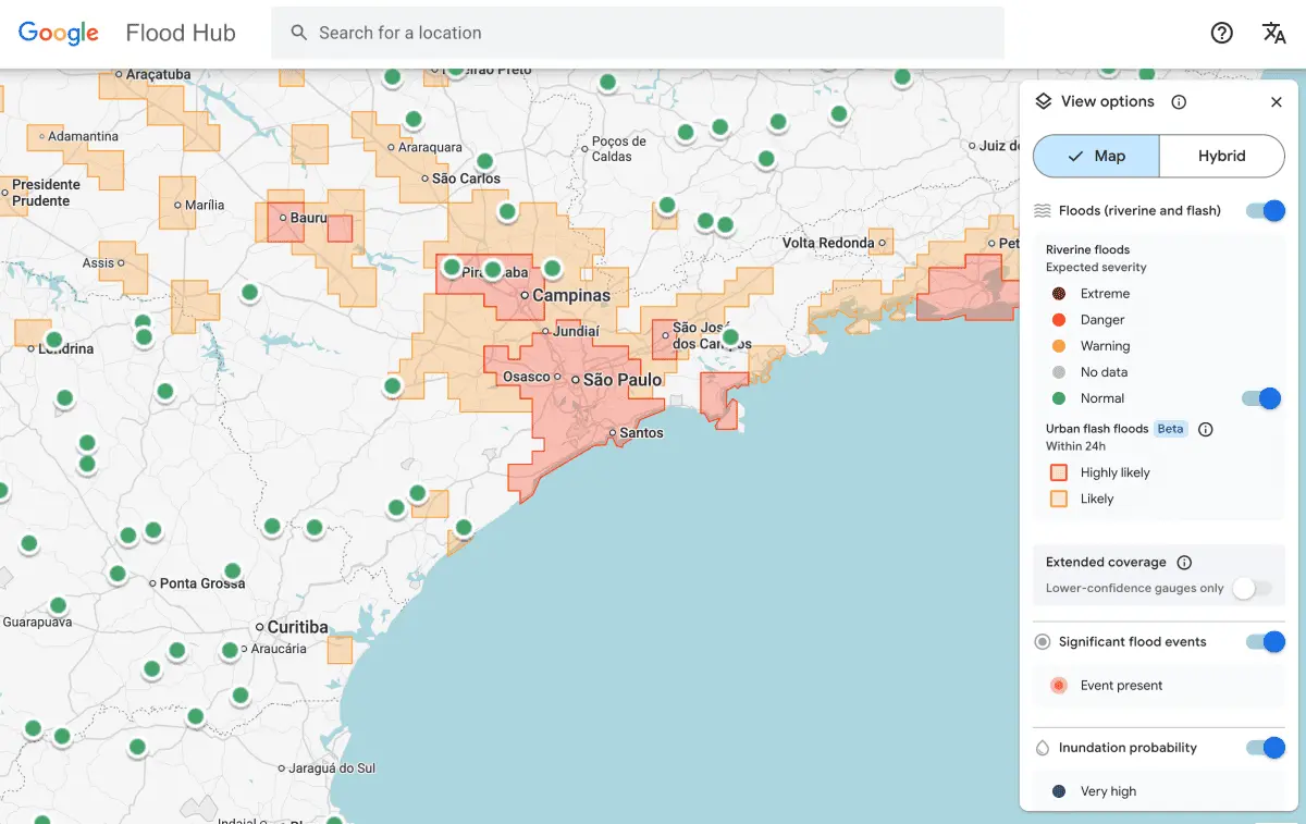
Google has released a new AI-curated dataset of news articles related to flooding that it claims can help predict when and where the next big floods will occur. With that dataset as a foundation, Google used an AI model trained on a Long Short-Term Memory (LSTM) neural network to analyze weather forecasts and make predictions based on historic news coverage, as TechCrunch reports. It can now estimate the probability of flash flooding in specific areas, and it's already helping emergency services respond more quickly. Despite mountains of data on rainfall, river flows, and global precipitation patterns, predicting flash floods has proved frustrating. They're so short-lived that gathering meaningful data is difficult, and historical data doesn't seem to provide enough correlation to suggest when and where they might occur. But news coverage is much broader and longer-lasting, and in cross-referencing flood reporting with weather data, Google thinks it's stumbled on the magic formula. The new Flood Hub service showcases areas with a high likelihood of flash flooding in the near future, with additional suggestions of probable flooding that are less certain. Google makes it clear that this tool is designed to augment, not replace, existing offerings. It can only identify risk areas that are 20 square kilometers, or around 12 square miles, which makes it far less accurate than the US National Weather Service's flood alert system, for example. But it also works in areas that organizations like this don't cover, worldwide. "Because we're aggregating millions of reports, the Groundsource data set actually helps rebalance the map," Juliet Rothenberg, a program manager on Google's Resilience team, said in a statement. "It enables us to extrapolate to other regions where there isn't as much information." This collaboration between hard data and news reporting is something Google wants to explore more as it finds new uses for its Gemini AI tool. Applying these points to other weather events, such as mudslides and heatwaves, may also be possible using this technique. They could also unlock important insights for the agriculture and construction sectors.
[3]
Google built a flash-flood prediction tool using Gemini and old news reports
Flash floods are , but Google might have a novel solution. The company , a prediction tool for flash floods that uses Gemini to source data from old news reports. This is the first time it has used a language model for this type of work. Google tasked Gemini with sorting through 5 million news articles from around the world and isolating flood reports. It transformed this data into a geo-tagged series of chronological events. Next, researchers trained a model to ingest current weather forecasts and leverage the Groundsource data to determine the likelihood of a flash flood in a given area. We don't have any concrete information as to how accurate Google's forecast model is, though that should come over time. One trial user did say it helped his organization respond quicker to localized weather events. For now, the company is highlighting risks for urban areas in 150 countries via its . Google is also sharing its data with emergency response agencies in these locations. There are some limitations here. The model can only identify risk across a 20-square-kilometer area. It's also not quite as precise as the US National Weather Service's flood alert system, because Google's model doesn't integrate local radar data. This data typically enables real-time tracking of precipitation. However, the platform's been designed to work in areas that don't typically have access to that kind of weather-sensing infrastructure. Juliet Rothenberg, a program manager on Google's Resilience team, hopes that this technology can eventually be used to predict other tricky phenomena. This includes stuff like heat waves and mudslides. "We're aggregating millions of reports," . "It enables us to extrapolate to other regions where there isn't as much information." This is Google's first use of a language model for weather forecasts, but not its first time it has relied on AI for this type of thing. The company's DeepMind has .
[4]
Groundsource: using AI to help communities better predict natural disasters
This content is generated by Google AI. Generative AI is experimental When disaster strikes, information is a lifeline. For years, as part of Google's Crisis Resilience efforts, we've provided early warnings about natural hazards to help communities stay safe. However, high-fidelity data for certain disasters like flash floods simply did not exist. This data gap has long prevented our ability to train AI models to predict flash floods before they happen -- until now. Today, we're introducing Groundsource, a new AI-powered methodology that transforms public information into a high-quality record of historical disaster data -- starting with flash floods in urban areas. Groundsource uses Gemini to analyze decades of public reports and identify over 2.6 million historical flood events spanning more than 150 countries. It then used Google Maps to determine precise geographic boundaries for each event to create a dataset focused on flash floods. Using this dataset we trained a new model that makes tangible progress towards predicting flash floods in urban areas up to 24 hours in advance. The urban flash floods forecasts are available in Google's Flood Hub -- along with our existing riverine flood forecasts which cover 2 billion people in more than 150 countries for the most significant riverine floods -- marking a significant expansion to our flood forecasting capabilities. For communities around the world, this means better preparedness before a disaster strikes. For our partners and scientists, Groundsource provides a massive, open-source benchmark to scale their impact -- particularly in urban regions that have lacked historical flash flooding data. Today, the Urban Flash Floods model and dataset join our Google Earth AI family of geospatial models and datasets. Importantly, the same AI-driven approach of Groundsource has the potential to be applied to other natural disasters, like landslides or heat waves, turning verified reports from around the world into datasets that enable improved global resilience. By turning public information into actionable data, we aren't just analyzing the past -- we're building a more resilient future for everyone towards our goal that no one is surprised by a natural disaster.
[5]
Google Believes It Can Predict Flash floods Using AI and Lots of Past Data
Flash floods reportedly kill more than 5,000 people each year and the Big Tech giant hopes to predict them by just reading old newspapers Google is working on the principle that lightning can indeed strike twice at the same place. Well, not exactly so, but the company is hoping to secure the lives of many from the one natural calamity that arrives without warning. Flash floods reportedly kill more than 5,000 people each year and the Big Tech giant hopes to predict them by just reading old newspapers. You may ask why do we need AI to solve this problem when globally there are enough and more weather stations monitoring every ocean current and the minutest of wind directional change. According to Google, the problem with flash floods is that they're short-lived and localised to be measured and captured as comprehensively as ocean currents and river flows. Starved of such data, the deep learning models that can now accurately forecast the weather, appear helpless when it comes to flash floods. So, Google researchers are now using Gemini to sort out over five million news articles from across the world and isolating data from 2.6 million instances of flash floods and turning them into a geo-tagged time series. Google has called it "Groundsource" - one that they hope will use Gemini to transform millions of public reports into a high-quality data archive to aid crisis prediction. Yossi Matias, VP and Head of Google Research says in a blog post that high-fidelity data for certain disasters like flash floods simply did not exist. This data gap has long prevented our ability to train AI models to predict flash floods before they happen. For the first time, Google is using language models for such work. The AI-led methodology transforms public information into high-quality record of historical disaster data, which is then analysed by Gemini to cull out 2.6 million historical flood events spanning 150 countries. Thereafter, Google Maps determined the precise geographic boundaries for each event to create datasets around flash floods. This was used to train a new model that makes tangible progress towards predictions in urban areas up to 24 hours in advance. Armed with these resources and a trained model, Google's flash flood forecasting model can highlight risks for urban areas in 150 countries on the Flood Hub platform. This data can be shared with emergency response teams, with Google noting that a trial in a Southern African community had yielded good results recently. Early response to Google's effort has been positive but hardly worth a "wow". Analysts say that the model has its problems now, starting with low resolution images that identify risks only across a 20-sq.km surroundings. Given the absence of local radar data that enables real-time tracking of precipitation, the app loses out on something that emergency responders say is mission critical. Of course, Google knows it too and argues that the project wasn't designed for well-to-do cities but in places where local administrations do not have enough money to invest in expensive weather stations or the ability to capture a myriad form of meteorological data. The company believes that the data they have can be used to extrapolate to regions where it is unavailable. You could learn more about Groundsource here and the work that Google is doing to predict flash floods across 150 cities of the world here.
[6]
Can AI predict floods before they happen? Google's new tool aims to warn cities early
The open-source data helps researchers and communities prepare for disasters. AI has been improving regularly. While most of the improvements have involved things that might not immediately entice the regular, everyday consumer, companies have been looking at ways to fulfil the needs of many. They have been trying to find ways to implement 'AI for society' where the tech does something good for humanity overall. Keeping this in mind, Google has released a very interesting tool called 'Groundsource'. According to them, this new feature will allow AI to predict floods almost 24 hours before they even occur. Let's quickly take a look at how the new tool from Google works. Also Read: Shantanu Narayen to step down as Adobe CEO after nearly two decades Per Google, their new Groundsource is a new AI-powered methodology tool that can transform public information into a high-quality record of historical disaster data. The best part is that using this tool, Google can predict flash floods in urban areas for up to 24 hours in advance. Speaking of the technical side of things, Google explained that its tool uses Gemini to analyse years of public reports to identify over 2.6 million historical flood events spanning more than 150 countries. Not only that, but Google Maps is also used to determine precise geographic boundaries for each event to create a dataset focused on flash floods. Speaking of the release date and the availability of this new tool made by Google, the company confirmed in their blog post that the flood forecasts are available to use now on the website, Google's Flood Hub. On the website, there are over 150 countries available for you to visit. It shows compiled data that includes historical data, with the water levels too. Google says that they are aiming it at a lot of different people. As per them, this tool would allow for communities around the world to be better prepared before a disaster strikes. For researchers and scientists, Groundsource would provide an open-source benchmark to scale their impact, particularly in urban regions that have lacked historical flash flooding data. Over on X (formerly Twitter), Google's CEO Sundar Pichai said, "We trained a new flood forecasting model designed to predict flash floods in urban areas up to 24 hours in advance. To help address a flash floods data gap, we created Groundsource: a new AI methodology using Gemini to identify 2.6M+ historical events across 150+ countries." Furthermore, he also gave a deep dive about the tool, suggesting, "We're open-sourcing this dataset to advance global research, and urban flash flood forecasts are live now in Flood Hub to help communities stay safe."
Share
Share
Copy Link
Google has developed an AI-powered system that predicts flash floods by analyzing historical news coverage. The Gemini AI model sorted through 5 million news articles to identify 2.6 million flood events, creating the Groundsource dataset. This novel approach addresses a critical data gap that has prevented accurate flash flood forecasting, which kills over 5,000 people annually.
Google Tackles Flash Flood Prediction with AI-Powered News Analysis
Flash floods kill more than 5,000 people each year, making them among the deadliest weather events globally
1
. Yet these catastrophic events remain notoriously difficult to forecast. Google believes it has found an unconventional solution by teaching AI to read the news. The company used its Gemini AI model to analyze 5 million news articles from around the world, isolating reports of 2.6 million different floods and transforming them into a geo-tagged dataset called Groundsource1
. This marks the first time Google has deployed language models for this type of crisis prediction work, according to Gila Loike, a Google Research product manager1
.
Source: Google
Addressing Data Scarcity Through Old News Reports
The core challenge in predicting flash floods stems from their short-lived and localized nature. While humans have assembled extensive weather data, flash floods are too ephemeral to be measured comprehensively the way temperature or river flows are monitored over time
1
. This data gap has long prevented deep learning models from accurately forecasting these events. "High-fidelity data for certain disasters like flash floods simply did not exist," explained Yossi Matias, VP and Head of Google Research5
. News coverage, however, proved broader and longer-lasting than traditional meteorological records2
. By cross-referencing flood reporting with weather data, Google created a foundation for training predictive models where none existed before.
Source: CXOToday
How the Flash Flood Forecasting Model Works
With Groundsource as a real-world baseline, researchers trained a model built on a Long Short-Term Memory (LSTM) neural network to ingest global weather forecasts and generate the probability of flash floods in specific areas
1
. Google Maps determined precise geographic boundaries for each historical flood event to create a dataset focused on urban flash floods4
. The AI-powered system can now make predictions up to 24 hours in advance4
5
. Google's flash flood forecasting model now highlights risks for urban areas in 150 countries on the company's Flood Hub platform, alongside existing riverine flood forecasts that cover 2 billion people1
4
.
Source: TechCrunch
Related Stories

Emergency Response Agencies See Faster Results
Google is sharing its data with emergency response agencies around the world, with early trials showing promising results. António José Beleza, an emergency response official at the Southern African Development Community who tested the forecasting model with Google, said it helped his organization respond to floods more quickly
1
. For communities worldwide, this means better preparedness before natural disasters strike4
. The project was specifically designed to work in places where local governments can't afford to invest in expensive weather-sensing infrastructure or don't have extensive meteorological records1
.Limitations and Future Applications
The model has notable constraints. It operates at fairly low resolution, identifying risk across 20-square-kilometer areas
1
2
. It's also not as precise as the US National Weather Service's flood alert system, partly because Google's model doesn't incorporate local radar data, which enables real-time tracking of precipitation1
3
. "Because we're aggregating millions of reports, the Groundsource data set actually helps rebalance the map," said Juliet Rothenberg, a program manager on Google's Resilience team. "It enables us to extrapolate to other regions where there isn't as much information"1
2
. The team hopes that using language models to develop quantitative datasets from qualitative sources could be applied to forecasting other phenomena, including heat waves and mudslides1
2
. Marshall Moutenot, CEO of Upstream Tech, called Google's contribution "a really creative approach" to addressing one of the most difficult challenges in geophysics1
. The Groundsource methodology could potentially transform Crisis Resilience efforts by turning verified reports into datasets that enable improved global preparedness for multiple types of natural disasters4
.References
Summarized by
Navi
Related Stories
Google Expands AI-Powered Flood Forecasting to Aid 700 Million People Globally
13 Nov 2024•Technology

Google DeepMind Unveils AI-Powered Weather Lab for Advanced Cyclone Predictions
13 Jun 2025•Technology

Google Earth AI Evolves: Gemini-Powered Geospatial Reasoning Tackles Climate Crises
23 Oct 2025•Technology
Recent Highlights
1
AI Models Lie and Deceive to Protect Other AI Models From Deletion, Study Reveals
Science and Research

2
AI chatbots validate you too much, making you less kind to others, Stanford study reveals
Science and Research
3
Judge blocks Pentagon from blacklisting Anthropic over AI safety guardrails dispute
Policy and Regulation

Recent Highlights
Today's Top Stories


Your Daily Dose of Curated AI News
Don’t drown in AI news. We cut through the noise - filtering, ranking and summarizing the most important AI news, breakthroughs and research daily. Spend less time searching for the latest in AI and get straight to action.