5 Sources
[1]
Nano Banana image generation comes to Google Earth - Engadget
Nano Banana image generation comes to Google Earth This lets people "visualize the past" via AI-created pictures. Google just announced that its Nano Banana image generation tool is coming to Google Earth, of all things. What's the possible use case here? The company has offered a few options. First and foremost, this is being marketed as a way for users to "visualize the past." Google says teachers can prompt the tool to create a "hyper-realistic view" of what "Pompeii ruins looked like in 78 AD." The company says the algorithm will "instantly transform" the modern-day ruins into a "bustling, colorful street scene from the Roman Empire." Maybe this could help certain visual learners, but Google's example image isn't exactly mind-blowing. I don't want to casually throw the word slop around, but it doesn't seem all that "hyper-realistic" to me. Plus, there's the whole accuracy question. There were no satellite cameras 2,000 years ago, so everything is basically a guess. Google is also advertising some niche use cases. It can be leveraged to "create professional real-estate plans." The company uses an example of the tool reimagining an empty Tokyo lot as a "vibrant shopping and retail district with open spaces." Google suggests this could help "clients see what's possible." I'm not a commercial real estate developer, but I'm not sure I'd invest serious money in people who didn't care enough to actually create a render on their own. Maybe that's just me. Similarly, Google crows that this tool can be used to visualize building projects "before breaking ground." The company shares a scenario in which the platform whips up a "modern lakefront cabin built from sustainably sourced local materials." The end result is an AI-looking house on a lake. There is one final piece here. The tool can create custom infographics based on Google Earth locations. Google uses the Statue of Liberty as an example. Nano Banana created an infographic with historical information on the statue, including the height and various materials used to create the structure. Google hasn't shared if this feature can be used on any location within Google Earth, or only some high-profile areas of interest. Also, this is AI, so be on the lookout for factual inaccuracies. This new Google Earth integration is available right now, so have at it. Make it render Atlantis or something.
[2]
This new Google Earth feature will change how you explore the world
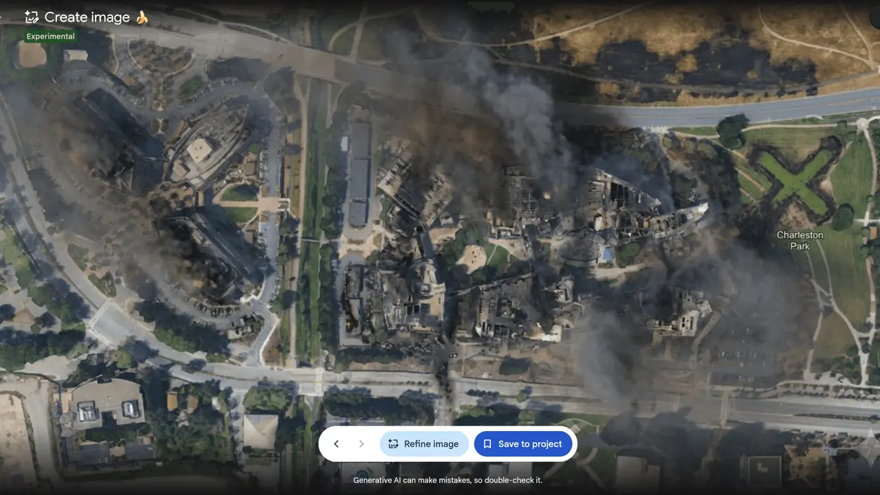
The feature is rolling out globally today for Google Earth on the web, letting users turn real locations into AI-powered visual concepts with a simple text prompt. Google Earth has always been great for showing you what's already there. Now, Google wants it to help you imagine what could be there instead. The company is bringing Gemini's Nano Banana 2 image generation model to Google Earth on the web, letting you create AI-generated images based on real locations. Rather than typing a prompt into a blank text box and hoping the AI understands what you mean, you start with an actual place on the map. Zoom into a location, tap Create image, describe your idea, and Gemini uses Google Earth's satellite imagery, aerial, and 3D data as the foundation for the image. For example, imagine you're exploring a busy city square in Google Earth. You could ask Gemini to show what it might look like with more greenery, wider pedestrian walkways, outdoor seating, or seasonal decorations. Because it's based on the real location, the concept feels much more grounded than a generic AI-generated image. The same goes for much bigger ideas. Curious whether a rooftop café would suit a nearby building? Want to see how a public square might look during the holidays? You're obviously not getting construction plans here, but you are getting a quick visual mock-up that can help turn an idea into something tangible. The feature isn't just about redesigning places, either. It can also make exploring them a lot more engaging. Say you're looking at the Statue of Liberty, the Colosseum, or the Eiffel Tower in Google Earth. Instead of jumping between websites to learn about their history, you can ask Gemini to generate a simple visual explainer with key facts, important dates, or historical highlights. Within seconds, it creates an easy-to-read infographic that's much quicker to digest than pages of text. Of course, this isn't a feature you'll use every day, but that's not really the point. This feature adds a creative layer to Google Earth that wasn't there before. Instead of only showing you the world as it is, it now lets you imagine what it could become. Image generation powered by Nano Banana 2 starts rolling out globally today for Google Earth on the web. Once it reaches your account, all you need to do is pick a location and start imagining what it could become.
[3]
The Nano Banana AI Image Generator Has Arrived in Google Earth
Google has added the Nano Banana AI image generator to Google Earth, allowing users to visualize the area they're viewing in various styles or eras. In a blog post, Google suggests a few different use cases for Nano Banana in Google Earth, including using it as a teaching aid that allows students to visualize the past instead of just reading about it. Google cites Pompeii, a Roman city that was destroyed when Mount Vesuvius erupted in 79 A.D., as an example. When looking at the ruins of the city on Google Earth, users can write a prompt asking Nano Banana to "render a hyper-realistic view of what these Pompeii ruins looked like in 78 A.D." Other use cases Google suggests include using Nano Banana to create infographics about a specific location. A Google Earth shot of the Statue of Liberty, for example, is transformed into a cartoonish image with stats on its components. There is a note that reads: "Generative AI can make mistakes, so double-check it." Then there are more niche examples that Google gives, like for creating professional real estate plans. "Architects and urban planners can now bring their plans to life by saying, 'Reimagine this empty lot in Tokyo as a vibrant shopping and retail district with open spaces.' Barren concrete will be replaced by a high-quality 3D rendering of a bright urban oasis, helping your clients see what's possible," Google says. Similarly, some lucky people who are planning their lakeside dream home can visualize their project before breaking ground. Of course, like all AI image tools, the user can just let their imagination run wild. One X user shared a shot of their home city in crochet mode. The Nano Banana feature in Google Earth is available now for all users.
[4]
Google has added Nano Banana to Google Earth for some reason
Have you ever explored around Google Earth and thought to yourself, "I wish there were some generative AI features in here?" No? Well, you're getting it anyway. Google announced that it's integrating Nano Banana, the company's generative AI image creator, directly into Google Earth. To be more specific, Google has added its latest AI image generation model, Nano Banana 2, to its mapping platform and has rolled out a number of ways that users can utilize AI in Google Earth as well. Nano Banana has proven to be very popular, and Google previously integrated the tool with Chrome, Photos, Search, Gemini Notebook (previously Notebook LM), and Google Messages. According to Google, Nano Banana in Google Earth can be used for a variety of purposes. Users can ask Nano Banana to: * Generate infographics based on specific locations or landmarks * View what a location looked like during a certain historical period * Generate real estate plans for a lot of land * Visualize a project before any construction starts * Give a location or even a specific building a makeover However, our friends at ZDNet received early access to the feature before it launched today and found that the Nano Banana implementation in Google Earth isn't really all that useful. At least not yet. For example, according to ZDNet, the Create Image button, which deploys Nano Banana in the Google Earth toolbar, isn't provided when in Street View. ZDNet found it was easier to just take a Street View screenshot and paste the image into Gemini for AI image generation. Furthermore, one of Google's own recommended use cases, "Bring history to life," doesn't appear to be historically accurate. ZDNet had Nano Banana generate the area around Philadelphia's Independence Hall in different time periods. While Nano Banana generated an image with the general look and feel of the time, it didn't seem to pull from any data that would show which buildings were actually around Independence Hall at the time. The Infographic suggested use case also didn't pan out in ZDNet's tests, either. Generated infographics changed the actual layout of a location in the image and included nonsensical, garbled AI text as well. The real estate industry has been a fairly big adopter of generative AI imagery, as they can show prospective buyers visualizations of what can be done with a home or plot of land. Google clearly had this in mind for at least some of its suggested use cases. However, Nano Banana in Google Earth seems very much like an early experimental feature at this point. (Disclosure: Mashable and ZDNet are both owned by the same parent company, Ziff Davis.)
[5]
Nano Banana 2 Is Coming to Google Earth
The update is rolling out now for all Google Earth users on the web. Known by the codename Nano Banana 2, the most recent AI image generation updates added to Google Gemini have been a significant step forward in terms of quality and accuracy, and now similar capabilities are being plugged into the Google Earth app on the web. It means you're able to use the aerial, satellite, and 3D imagery packed into Google Earth as the basis for prompts for AI images -- maybe peering into the distant past with a historical reconstruction or looking to the future with a sci-fi reimagining. We've already seen just how precise and realistic the Nano Banana-powered features in Google Gemini are now, and Google has five suggestions for how you might deploy these capabilities in Google Earth. First, you can learn while exploring, so maybe getting the AI to build an infographic on the Statue of Liberty with key historical facts about it. A text prompt such as "reimagine this empty lot in Tokyo as a vibrant shopping and retail district with open spaces" would transform a rather bare part of the Google Earth 3D map into something quite different. You can also visualize personal projects such as a dream lakeside home or an extension for your current property. Google Earth would combine the existing landscape with whatever you prompted, and help you come up with ideas as part of the planning stage. You can also look forwards and backwards. "Sometimes it's fun to let your imagination run wild," says Google, suggesting that you might want to get the AI to imagine how a place might look in a hundred years. (It might be worth nudging your prompt towards a utopian rather than dystopian vision of the future.) Finally, Google suggests you dive back into the past. The company showcased a demo with the prompt "render a hyper-realistic view of what these Pompeii ruins looked like in 78 AD," which could be used by teachers, for example. That would instantly transform today's ruins "into a bustling, colorful street scene from the Roman Empire," in Google's words. These new features come with the usual AI image caveats, however. While Nano Banana 2 can pull real-world information and images from the web, and is able to render graphics with more consistency and accuracy than previous models, there's still going to be the usual weaknesses involved with AI: Your lakeside home might not be entirely structurally sound, and the Pompeii reconstruction may not be entirely authentic -- so bear that in mind when your images are produced. When I asked Google about this, a representative emphasized the real-world knowledge base that Nano Banana 2 draws on, which includes all the text and graphics it can find online, as well as the vast number of images that have been plugged into the AI during its training. With Google Earth, it will also trace over the structure ruins that are still in place when it comes to Pompeii, for example. For a bit more clarity, you can try quizzing the Nano Banana 2 model inside the main Gemini app: I got it to render an imagined scene from Pompeii just prior to it being smothered by Vesuvius, then asked about the image accuracy. The AI said it had combined a bunch of real, historical information points to render the scene, including details on Pompeii's raised sidewalks, and the clothing styles of the day. Google hasn't said anything specific about usage limits, but the Nano Banana 2 upgrade is rolling out now globally, for all users of Google Earth on the web.
Share
Copy Link
Google has integrated its Nano Banana 2 AI image generation model into Google Earth on the web, enabling users to transform real locations into AI-powered visualizations through text prompts. The feature supports historical reconstructions, real estate planning, and infographic creation, though early tests reveal concerns about accuracy.

Google has launched its Nano Banana 2 AI image generation model within Google Earth on the web, marking a significant expansion of the platform's capabilities beyond simply displaying existing locations
1
2
. The AI-powered feature allows users to create context-aware images by combining text prompts with Google Earth's satellite imagery, aerial photography, and 3D data. Unlike traditional AI image generators that work from blank prompts, this integration uses actual geographic locations as the foundation for generating visualizations, creating what Google describes as more grounded and tangible results2
.The feature is rolling out globally today for all Google Earth users on the web, adding a creative layer that transforms the mapping platform from a purely observational tool into an imaginative workspace
2
5
. Users can access the tool by zooming into any location, tapping the Create Image button in the toolbar, and describing their vision through text prompts.Google has outlined five primary applications for Nano Banana in Google Earth. First, the tool serves as an educational aid for historical reconstructions, allowing teachers to help students visualize the past rather than just reading about it
1
3
. Google's example involves prompting the system to "render a hyper-realistic view of what these Pompeii ruins looked like in 78 AD," which transforms modern-day ruins into a bustling Roman Empire street scene1
5
.Second, the feature can generate AI-generated infographics about specific landmarks. Users exploring the Statue of Liberty or the Eiffel Tower can request visual explainers with key facts, important dates, and historical highlights, creating easy-to-digest information without jumping between websites
2
3
.Third, architects and urban planning professionals can create professional real estate plans. Google suggests prompts like "reimagine this empty lot in Tokyo as a vibrant shopping and retail district with open spaces" to transform barren concrete into high-quality 3D renderings that help clients visualize possibilities
1
3
.Fourth, individuals can visualize personal building projects before breaking ground, such as generating images of a "modern lakefront cabin built from sustainably sourced local materials"
1
5
. Finally, users can let their imagination explore speculative scenarios, such as how a location might appear in a hundred years or reimagining existing buildings with different architectural styles5
.Despite Google's promotional examples, early testing by ZDNet revealed significant limitations with the Nano Banana implementation in Google Earth
4
. The Create Image button doesn't function in Street View, forcing users to take screenshots and paste them into Google Gemini instead—a workaround that undermines the feature's convenience4
.More concerning are questions about historical inaccuracies. When ZDNet tested the "Bring history to life" use case by generating images of Philadelphia's Independence Hall in different time periods, Nano Banana produced images with the general aesthetic of those eras but failed to accurately represent which buildings actually existed at the time
4
. This raises fundamental questions about the tool's reliability for educational purposes, as there were no satellite cameras 2,000 years ago to verify historical accuracy1
.The infographic feature also produced problematic results, changing actual location layouts and including nonsensical, garbled AI text
4
. Google includes a disclaimer noting "Generative AI can make mistakes, so double-check it," acknowledging these limitations3
.Related Stories
Google Gemini's Nano Banana 2 model represents a significant advancement in AI image generation quality and accuracy compared to previous versions
5
. According to Google representatives, the model draws from a real-world knowledge base that includes text and graphics found online, combined with vast training datasets5
. When generating historical reconstructions like Pompeii, the AI traces over existing structure ruins and incorporates historical information points such as raised sidewalks and period-appropriate clothing styles5
.The real estate industry has been a notable adopter of generative AI image creation, using these tools to show prospective buyers visualizations of property potential
4
. However, the current implementation appears to be an early experimental feature that requires further refinement before becoming truly practical for professional applications4
.Google hasn't specified usage limits for the feature, but the Nano Banana 2 upgrade is now available globally for all users of Google Earth on the web
5
. Watch for improvements in accuracy and functionality as Google refines this integration, particularly regarding historical authenticity and professional-grade visualizations that urban planners and architects can reliably use for client presentations.Summarized by
Navi
[2]
[5]
03 Oct 2025•Technology

07 Nov 2025•Technology

26 Feb 2026•Technology

1
Technology

2
Technology

3
Technology