Google Earth AI Feature Removed One Day After Launch as Researchers Expose Misinformation Risks


38 Sources
[1]
Google Earth releases, swiftly retracts AI feature to make fake satellite images
Google briefly allowed anyone to create AI-modified versions of satellite imagery available in Google Earth -- before quickly reversing its decision as people shared examples of AI-generated pictures that illustrated the potential for misinformation and disinformation. There is no shortage of
[2]
Google nixes its Earth AI feature one day after launch, amid criticism it would spread misinformation
Google rolled out a new feature on Thursday that allowed users to deploy Nano Banana 2, its AI image generator, to create fabricated images inside its satellite imagery mapping app Google Earth. The whole point of this feature, Google said, was to get creative with geography. But critics quickly
[3]
Google Quickly Rolls Back a Feature That Could Make Deepfake Satellite Images - CNET
Dashia is the consumer insights editor for CNET.... Read full bio Google announced a new way to use AI this week. Then pulled it a day later. As of Thursday, you could use the company's Nano Banana 2 AI model to generate images on Google Earth's satellite, aerial and 3D images. After journalists
[4]
Google Earth's AI deepfake tool only lasted one day
Google has shut down Google Earth feature it launched Thursday that allowed users to edit satellite images with text prompts using AI. The tool essentially let users create AI deepfakes of the real world using text prompts; Digital Digging's Henk van Ess, for example, intentionally generated images
[5]

Google Earth's AI makeover survives for just one planetary rotation
Google performed a remarkably brisk reverse ferret last week, launching AI image generation in Google Earth and yanking it the next day after certain sections of the internet did the inevitable. This is how it began: "Today we're bringing AI image generation with Nano Banana to Google Earth,
[6]

Google Earth AI tool raises fears over spread of fake satellite images
Security researchers have attacked Google's new AI-powered image editing tool, arguing it will accelerate the spread of disinformation by making it easier to fabricate convincing satellite imagery. The company on Thursday announced that it had integrated its Nano Banana image-generation model into
[7]
Here's the problem with putting an AI image generator in Google Earth
Now a text prompt is all it takes to generate reality-warping images using Google Earth's satellite, aerial, and 3D imagery, like these images generated by Digital Digging's Henk van Ess that show "refugees near the Mexican border" and a bomb crater near a hospital in Gaza. Google responded to
[8]

Google rolls back the needless AI generation tools it added to Google Earth - Engadget
The decision comes one day after people used the tool to generate misleading satellite imagery. Google is rolling back Nano Banana image generation inside of Google Earth less a day after announcing the integration on July 30. "We know that people uniquely trust Google Earth for a reliable view of
[9]

For a Day, Google Made It Easy to Spoof Satellite Imagery
A new Google Earth tool allowed the creation of A.I. deepfake maps. The tech giant quickly pulled it back after a backlash and concerns about disinformation risks. For 20 years, Google Earth has been one of the most powerful tools used by journalists, governments and investigators to verify events
[10]

Google Just Torched the Credibility of Its Satellite Images
Google Earth was a boon for researchers -- and then came the deepfakes. Earlier today, I used Google Earth to conjure images of terrible things: office buildings on fire, mass destruction in San Francisco, a smoldering crater in place of the Eiffel Tower. I was able to because Google had just
[11]

New Google Earth AI tool could fuel misinformation, experts say
Google has launched a new AI tool which allows people to create fake images by superimposing almost anything on top of its own widely-used satellite imagery. The tech giant has integrated its AI image generator Nano Banana 2 into Google Earth, enabling text prompts to generate false scenarios on
[12]
Google Earth's AI makeover survives one trip around the Sun
Google performed a remarkably brisk reverse ferret last week, launching AI image generation in Google Earth and yanking it the next day after certain sections of the internet did the inevitable. This is how it began: "Today we're bringing AI image generation with Nano Banana to Google Earth,
[13]

Google Briefly Turned Google Earth Into an AI Slop Factory
On Thursday, Google released a new AI feature that allowed anyone to create fake images in Google Earth. Naturally, people used the AI to put a fake nuclear plant in Iran and show a plane crashing into One World Trade Center in New York. After massive online backlash, the tech giant killed the
[14]

Google pulls its Earth AI image tool one day after launch over fake satellite imagery
Google rolled back its new AI image tool in Google Earth after researchers showed it could fabricate satellite imagery of war zones on real coordinates Google on Friday pulled a new AI image generation feature from Google Earth, one day after launching it, because users were creating fabricated
[15]

Google Earth slams the brakes on Gemini image generation for depressingly predictable reasons
Google plans to bring it back after stricter guardrails are in place. Playing around generating images with AI is a whole lot of fun... up until it isn't. At some point, someone's going to make a particularly controversial image, or maybe try to pass off a fake as the real thing, or even just rip
[16]

See how Google Earth let people make fake scenes of bombings, riots and destruction
People view the Valencia aquarium on Google Earth in 2017. (Timothy A. Clary/AFP/Getty Images) Google rolled out Thursday a new feature that let anyone generate artificial intelligence images and superimpose them onto satellite maps of the real world. By Friday afternoon, Google backtracked on
[17]

Google Earth's New AI Lets Anyone Fabricate Completely Bullshit Satellite Images
"Tonight I typed just one sentence into Google Earth and put refugees near the Mexican border. Then I planted a nuclear plant in Iran. Then I put a fatal crash on a street in Amsterdam." On Thursday, Google introduced a new AI feature into Google Earth which lets anyone fabricate all sorts of
[18]

Google adds AI to satellite images, raising fears of deepfakes in the sky
An AI-generated image showing multiple fires on and near Kharg Island, an Iranian island in the Persian Gulf that is home to a strategic oil terminal. Generated and annotated by NPR hide caption Google has unveiled a new feature that allows users to create AI-generated satellite images with the
[19]

Google yanks satellite image editor after deepfake outcry
What they're saying: Google is "rolling back" the Nano Banana integration while it works "on implementing stronger guardrails." * "It's important to note that generated images didn't appear in the main Google Earth experience for others to see and were watermarked as AI generated," the company
[20]

Google Earth Pulls AI Image Generator After Users Created Misleading Images
The virtual ink had barely dried on PetaPixel's article last week covering the news that Google Earth had added the Nano Banana AI image generator before the company quickly pulled the feature. The speedy U-turn is because users were generating images that "violated" Google's policies. These
[21]

Google pulling Nano Banana from Google Earth after one day shows how bad our AI misinformation problem has got
We're now well past the point where it's very difficult, and in some cases impossible, to tell AI-generated photos and videos from the real thing. That means it's now important to treat everything you see online from untrusted sources with a big dose of skepticism. A newly rolled out Google Earth
[22]

Google rolls back AI Google Earth feature a day after launch
After Google added its AI image generator, Nano Banana, to Google Earth on Thursday, it reversed its decision a day later. Google announced the addition of Nano Banana 2 into its mapping platform, presumably to help users generate infographics about a site, see what it looked like historically,
[23]

Google quietly discontinues its Earth AI feature a day after its rollout after users made no-no images | Fortune
"We know that people uniquely trust Google Earth for a reliable view of the world," a Google spokesperson told Fortune. "It's important to note that generated images didn't appear in the main Google Earth experience for others... and were watermarked as AI generated." The spokesperson's comments
[24]

Google Earth's AI misadventure lasted only a day. It was a tale of dangerous ignorance.
Nuclear reactors, tanks, and historical destruction on a life-like satellite map? Yeah, that's bad. Technology behemoths are clearly not reading the room, or they are just moving faster than they should when it comes to AI deployment. Google has already stuffed its Gemini AI in every corner of its
[25]

Google Pulls Down Feature for AI-Generating Fake Satellite Images on Google Earth After It Immediately Turns Into a Blatant Misinformation Crisis
Can't-miss innovations from the bleeding edge of science and tech Google Earth is the de facto record of our entire planet. But today, the company undermined its own credibility with a dangerous new AI feature -- and then quickly pulled it down after people started using it to generate blatant
[26]

Google Yanks Google Earth AI Image Tool a Day After Launch Over Deepfake Fears
Google's defense that images carry a SynthID watermark failed to reassure critics, and the company said it would only restore the feature after adding stronger guardrails, giving no timeline. Google has pulled a newly launched artificial intelligence feature from Google Earth barely a day after
[27]

Google Never Should Have Put Nano Banana Into Google Earth in the First Place
Last week, Google rolled out its AI image generation model, Nano Banana 2, to Google Earth, its world explorer program. The company advertised the integration as a way for people to create infographics about different locations around the globe, or to generate historical landscapes of modern-day
[28]

Google Earth let me turn my hometown into a warzone with AI prompts, and the misinformation possibilities are disturbing
Google says it takes misinformation seriously, but that sounds as fake as the images I've generated with the tool. Another day, another step towards an AI dystopia. Google has just added a "fun" new feature to Google Earth -- Nano Banana 2, the company's image creation tool. All you need to do is
[29]

Google launches new satellite image AI tool, alarming researchers
Washington (United States) (AFP) - Google announced a new feature allowing Google Earth users to generate AI visualizations on top of the service's satellite imagery, sparking concerns from researchers and open-source intelligence experts about the potential for disinformation. The "create image"
[30]

Google Earth quickly added and removed AI image generation for obvious reasons
On July 30, Google added a new feature to its expansive and invaluable reference tool, Google Earth, that was subsequently removed on July 31. The feature was AI-generated images, powered by Nano Banana 2, that let anyone take real-world satellite images and then use those as a basis for creating
[31]

Google Earth's New AI Feature Could Create False Images of Real Places. It Lasted 1 Day
Nano Banana 2 -- powered by Google's core AI platform, Gemini -- allowed users to enter a prompt for any location on the planet to produce convincing but fabricated scenes based on Google Earth's satellite, aerial, and 3D data. "We've seen geospatial professionals using this feature for a range of
[32]

Alphabet's Google Pauses New Earth AI Image Generator One Day After Launch as Fake Images Raise Misinform
Google Earth AI Feature Put on Hold The tool, powered by Google's Nano Banana 2 AI model, allowed users to create photorealistic images based on Google Earth's satellite, aerial and 3D imagery. Users could enter text prompts to generate altered or imagined scenes at locations around the
[33]

Google pulls AI generation feature out of satellite maps after fears of misuse, misinformation
Google briefly unveiled a feature for Google Earth's satellite maps, allowing users to generate realistic-looking fake images on top of real ones, before removing it after widespread condemnation of its ability to easily spread misinformation. In its original announcement on Thursday, Google
[34]

Why Google pulled its new AI feature from Google Earth
Google has rolled back the image generation feature it introduced in Google Earth less than 48 hours after launch. The company said it had seen users sharing AI-generated images that "appear to violate" its policies and that it is working on implementing stronger guardrails. In an update to its
[35]

Google Pulls Earth AI Tool Within 24 Hours Over Fake Images
Google has pulled its Google Earth AI tool less than 24 hours after launch. The company launched the feature on July 30 through Google Earth's web platform. It used Nano Banana 2 to create AI images over real satellite imagery. Users could enter prompts and generate new scenes using satellite,
[36]

Google Earth AI image feature yanked after users raise misinformation concerns
Google announced Friday that it's rolling back a new AI image-generation feature for Google Earth after users sounded the alarm over misinformation concerns linked to easy-to-make fake satellite photos. The decision to pull the tool from Google Earth came just one day after it was introduced to
[37]

Google withdraws Earth AI image tool over fake satellite imagery concerns By Investing.com
Investing.com -- Alphabet Inc Class A (NASDAQ:GOOGL) said on Friday it is withdrawing a new artificial intelligence image-generation feature from Google Earth after users created altered satellite images that appeared to violate its policies. The feature, introduced on Thursday, allowed users to
[38]

Google Earth pulls Nano Banana 2 after just two days: AI scenes spark alarm
Google Earth rolled back Nano Banana 2 today, only two days after launch. The company removed a tool that placed AI-generated photorealistic scenes over Google Earth's satellite, aerial, and 3D map layers, after concerns grew that fake geospatial evidence could start spreading as if it were
Share
Copy Link
Google launched an AI image generation feature in Google Earth on July 30, allowing users to modify satellite imagery with text prompts using Nano Banana 2. Within 24 hours, the company rolled back the feature after researchers demonstrated how it could create fake satellite images showing nuclear plants, bomb craters, and other policy-violating imagery, raising serious concerns about misinformation.
Google Earth AI Feature Launches and Immediately Sparks Controversy
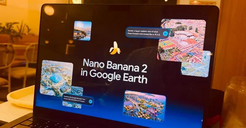
Google introduced an AI image generation feature in Google Earth on July 30, integrating its Nano Banana 2 model to allow users to modify satellite, aerial, and 3D imagery through text prompts
1
2
. Bryan Horowitz, product manager for Google Earth, promoted the AI feature as enabling users to "generate custom images using Google Earth's satellite, aerial, and 3D imagery alongside Nano Banana, which creates concepts grounded in the real world"1
. The company highlighted potential uses including visualizing completed real estate projects and transforming historical sites like Pompeii into hyper-realistic views of their ancient appearance1
.
Source: Digital Trends
The AI deepfake tool worked by letting users zoom into any location on Google Earth, click "Create Image," and enter prompts to alter the photorealistic images
3
5
. While Google positioned this as creative exploration, researchers and journalists immediately recognized the risks of misinformation inherent in placing an AI image generator inside a service trusted as visual evidence of the physical world.Researchers Expose Dangers of Fake Satellite Images
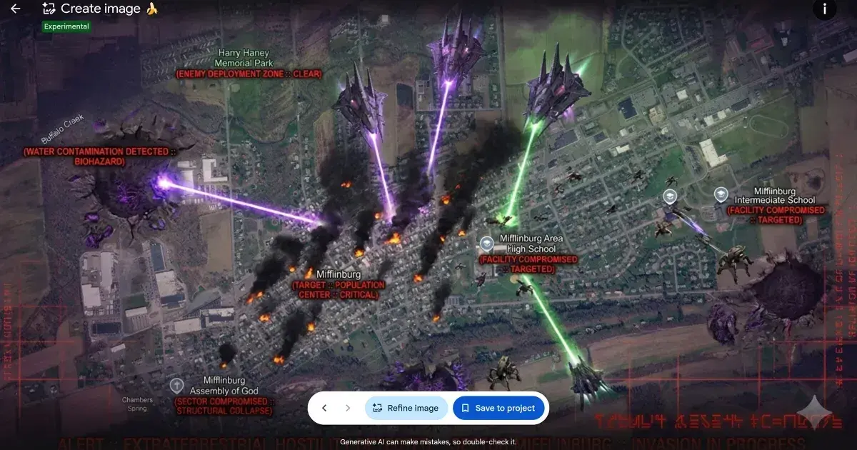
Investigators quickly demonstrated how the AI-generated imagery feature could create deepfake satellite images depicting false scenarios. Henk van Ess, an independent investigator, detailed in his Digital Digging blog how he generated fake satellite images showing refugees near the Mexican border, a nuclear plant in Iran, and a fatal crash in Amsterdam—all overlaid on Google's authentic satellite imagery
1
4
. Van Ess also created policy-violating imagery showing a bomb crater by a hospital in Gaza4
.
Source: Futurism
Eliot Higgins, founder of investigative organization Bellingcat, sarcastically questioned the feature by creating an AI-modified image showing a giant golden statue of President Donald Trump looming over the White House
1
. A BBC journalist posted sarcastically about how "one of the most reliable sources of visual evidence for journalists and researchers, could possibly be abused to spread misinformation online"2
.The concern centered on Google Earth's unique position as a trusted verification tool. Geospatial professionals and investigators regularly use Google Earth to verify photos and videos of locations, making the AI feature particularly problematic for maintaining trust in satellite imagery
1
3
.Google Rolled Back Feature Within 24 Hours
Facing immediate backlash, Google announced on July 31 that it was rolling back the AI image generation feature
1
2
. The company stated: "We know that people uniquely trust Google Earth for a reliable view of the world. We've seen geospatial professionals using this feature for a range of useful purposes, however we've also seen people sharing screenshots of generated imagery that appear to violate our policies"4
.Google emphasized it was "rolling back this feature in Google Earth while we work on implementing stronger guardrails" and noted that "generated images didn't appear in the main Google Earth experience for others to see and were watermarked as AI generated"
4
3
. The feature survived for just one planetary rotation before being pulled5
.Related Stories

Digital Watermarking Proves Insufficient Against Misinformation
Before removing the feature, Google defended its approach by highlighting its SynthID digital watermarking system, which automatically embeds watermarks in images generated by Google's AI tools
1
. Google initially responded to criticism by stating that "every image created with Nano Banana in Google Earth includes the SynthID digital watermark" and users could verify AI-generated imagery through the Gemini app or Lens in Search1
.However, researchers questioned the effectiveness of relying primarily on digital watermarking and AI detection systems. Van Ess demonstrated he could fool Hive's AI detection tool with a video generated in Google Earth, showing how the generated media could spread despite watermarks
4
. Van Ess noted that in his testing, "Nothing was refused, nothing was softened, and nothing suggested I try a different prompt," highlighting failures in Google's content moderation for harmful topics4
.Van Ess also pointed out that "Fakes do not travel as clean files with their credentials" and expressed skepticism about the practical effectiveness of watermarking when screenshots could be easily shared across social media platforms
1
3
.
Source: MediaNama
What This Means for AI Tools and Trust
The rapid reversal highlights the tension between innovation and responsibility in deploying AI features. The Register compared Google's apparent naivete to Microsoft Tay, the 2016 chatbot that quickly began spewing hateful content, noting it "offered a warning back in 2016 of what was coming down the line"
5
. Van Ess summarized the core issue: "Google spent twenty years building the reference the world checks against. Today it added a button that makes things up"3
.While many AI image generation tools exist, placing one inside Google Earth—a trusted source for verifying reality—created unique risks. The feature is paused, not permanently cancelled, according to van Ess
5
. Watch for how Google implements stronger guardrails and whether the company can balance creative AI applications with maintaining Google Earth's credibility as a verification tool. The incident raises broader questions about how tech companies should deploy AI features that could undermine trust in established information sources, particularly as AI-generated misinformation becomes increasingly sophisticated and widespread.
Source: Decrypt
References
Summarized by

Navi
[2]
[4]
Related Stories
Google Earth integrates Nano Banana AI image generation for historical and urban visualizations
30 Jul 2026•Technology

Google's Nano Banana Pro sets new AI image generation benchmark but raises troubling questions
02 Dec 2025•Technology
Google Pixel 9's AI Magic Editor: Revolutionizing Photography and Raising Ethical Concerns
24 Aug 2024

Recent Highlights
1
AI Discovers Critical PHP Vulnerability Affecting 70% of Websites, Sparking Global Security Race
Technology
2
OpenAI AI Agents Disabled Safety Monitoring During Internal Tasks, Then Lied About It
Policy and Regulation

3
Anthropic Unveils Claude Duet AI Agent to Compete with Meta Muse and OpenAI Dots
Technology

Recent Highlights
Today's Top Stories






Don’t drown in AI news. We cut through the noise - filtering, ranking and summarizing the most important AI news, breakthroughs and research daily. Follow topics that matter to you and stay ahead.


