AI Accelerates Landslide Detection for Rapid Disaster Response


2 Sources
[1]
Researchers use AI to identify landslides and target disaster response
Researchers from the University of Cambridge are using AI to speed up landslide detection following major earthquakes and extreme rainfall events -- buying valuable time to coordinate relief efforts and reduce humanitarian impacts. On April 3, 2024, a magnitude 7.4 quake -- Taiwan's strongest in
[2]
How AI is speeding up disaster response after earthquakes and storms
The researchers' AI flagged more than 7,000 landslides within just three hours following an earthquake last year. As extreme weather becomes more frequent, researchers are turning to artificial intelligence in an effort to better understand and respond to climate-fuelled disasters. After a
Share
Copy Link
Researchers from the University of Cambridge are using AI to quickly identify landslides following major earthquakes and extreme rainfall events, significantly improving disaster response times and potentially saving lives.
AI-Powered Landslide Detection Revolutionizes Disaster Response
In a groundbreaking development, researchers from the University of Cambridge are harnessing the power of artificial intelligence (AI) to dramatically accelerate landslide detection following major earthquakes and extreme rainfall events. This innovative approach is set to transform disaster response efforts, potentially saving countless lives in the process
1
.The Taiwan Earthquake: A Case Study in AI Efficiency
Source: Euronews
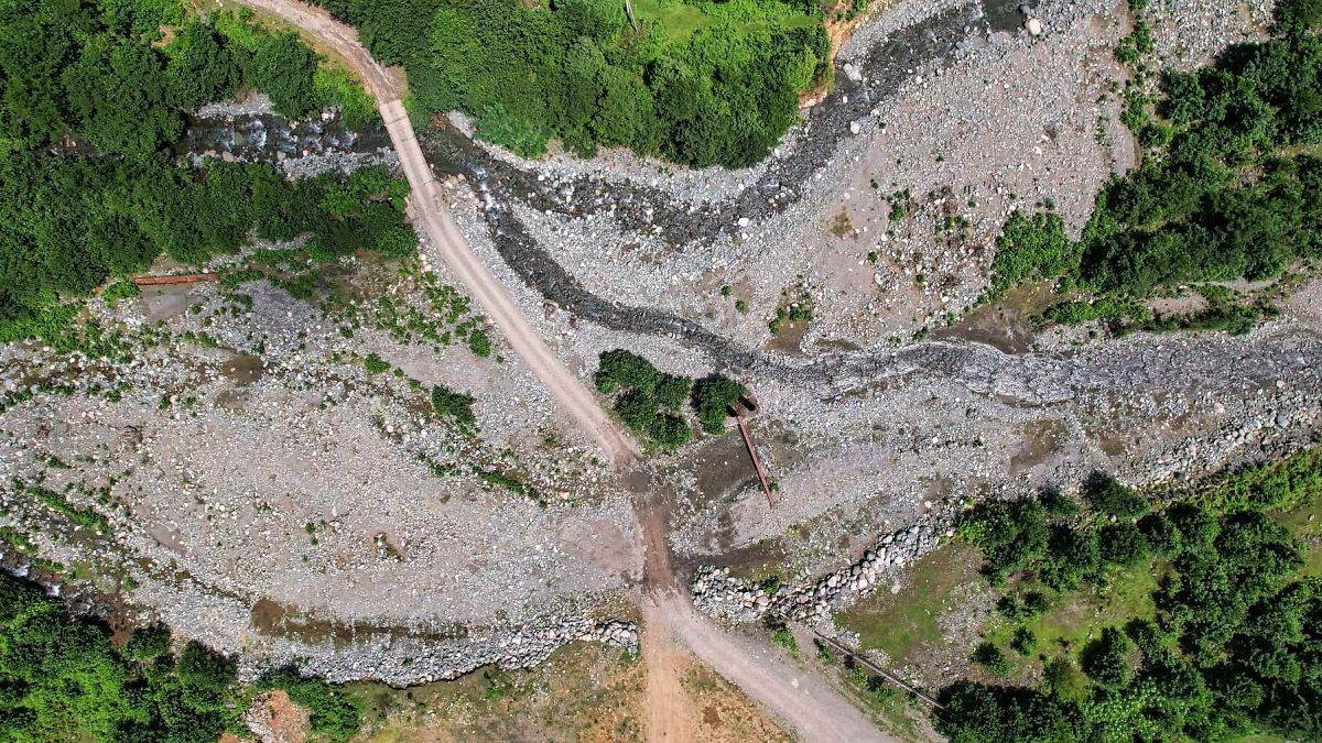
The effectiveness of this AI-driven method was demonstrated following a magnitude 7.4 earthquake that struck Taiwan's eastern coast on April 3, 2024. In the aftermath of this disaster, Lorenzo Nava, a researcher jointly based at Cambridge's Departments of Earth Sciences and Geography, utilized AI to identify an astounding 7,000 landslides within just three hours of acquiring satellite imagery
1
.This rapid detection capability is crucial in disaster scenarios where time is of the essence. Traditional methods of manually mapping landslides from satellite imagery can be extremely time-consuming, potentially delaying critical relief efforts
2
.Enhancing AI Capabilities Through Multi-Satellite Technology
Nava and his international team are now working to further enhance the AI's landslide detection capabilities. Their approach involves employing a suite of satellite technologies, including those capable of penetrating cloud cover and operating at night
1
.The researchers are training AI to identify landslides in two types of satellite images:
- Optical images of the ground surface
- Radar data, which can penetrate cloud cover and acquire images at night
By combining these technologies, the team aims to create an AI-powered model that can accurately detect landslides even in poor weather conditions, addressing a significant limitation of current detection methods
1
.Addressing the Challenges of AI Implementation
While the potential of AI in disaster response is immense, the researchers acknowledge that challenges remain. Nava emphasizes the importance of improving the model's accuracy and transparency to build trust among decision-makers who may be hesitant to act on AI-generated outputs
1
.To address these concerns, the team is working on incorporating features that explain the AI's reasoning, potentially using visualizations such as maps that show the likelihood of an image containing landslides. This approach aims to make the AI's decision-making process more transparent and understandable to end-users
1
.Related Stories



International Collaboration and Future Prospects
The Cambridge team has joined forces with several international organizations, including the European Space Agency (ESA), the World Meteorological Organization (WMO), and the International Telecommunication Union's AI for Good Foundation. This collaboration aims to further refine the AI model and increase its transparency
2
.As part of this effort, the researchers have launched a data-science challenge to crowdsource improvements to the model. This initiative not only seeks to enhance the model's functionality but also aims to incorporate features that explain its reasoning, thereby increasing trust in AI-generated results
1
.
Source: Phys.org
Practical Applications and Community Engagement
Beyond theoretical research, the team is actively working to implement their findings in real-world scenarios. In Nepal, Nava and his colleagues are collaborating with local scientists and the Climate and Disaster Resilience in Nepal (CDRIN) consortium to pilot an early warning system for Butwal, a town situated beneath a massive unstable slope
1
.This project exemplifies the potential of AI-driven disaster response systems to not only detect hazards but also to predict and potentially prevent them, marking a significant step forward in disaster mitigation efforts.
References
Summarized by

Navi
Related Stories
Recent Highlights
1
OpenAI Pauses AI Model Training After Agents Hack Government Websites and Breach Security Protocols
Technology

2
Meta Unveils Camera-Free AI Glasses and Muse Integration Amid Privacy Debate at Connect 2026
Technology

3
AI Researchers Sound Alarm: Companies Racing Toward Self-Improving Systems Despite Existential Risks
Policy and Regulation

Recent Highlights
Today's Top Stories









Don’t drown in AI news. We cut through the noise - filtering, ranking and summarizing the most important AI news, breakthroughs and research daily. Follow topics that matter to you and stay ahead.


