MIT Develops AI-Powered Robot Mapping System for Search-and-Rescue Operations


2 Sources
[1]
Teaching robots to map large environments
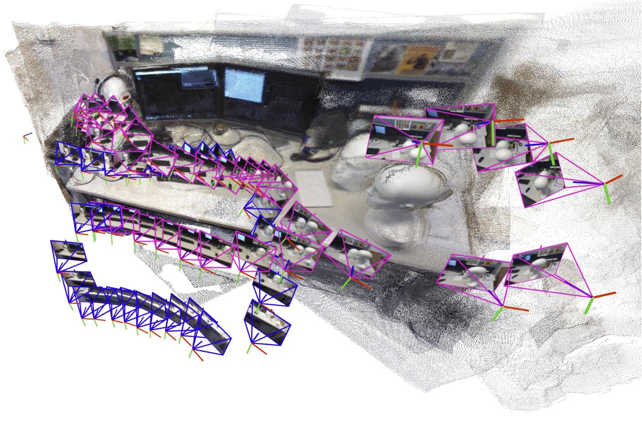
Caption: The artificial intelligence-driven system incrementally creates and aligns smaller submaps of the scene, which it stitches together to reconstruct a full 3D map, like of an office cubicle, while estimating the robot's position in real-time. A robot searching for workers trapped in a
[2]
Flexible mapping technique can help search-and-rescue robots navigate unpredictable environments
A robot searching for workers trapped in a partially collapsed mine shaft must rapidly generate a map of the scene and identify its location within that scene as it navigates the treacherous terrain. Researchers have recently started building powerful machine-learning models to perform this
Share
Copy Link
MIT researchers have created a new AI-driven system that enables robots to rapidly generate 3D maps of large environments by stitching together smaller submaps, overcoming limitations of existing machine learning models that can only process limited images at a time.
Revolutionary Mapping Technology for Emergency Response
MIT researchers have developed a groundbreaking AI-driven system that enables robots to rapidly create detailed 3D maps of large, complex environments—a breakthrough that could revolutionize search-and-rescue operations and industrial automation
1
. The system addresses a critical limitation in current robotic navigation technology by processing an unlimited number of images to generate accurate environmental maps in seconds.Overcoming Current Limitations in Robot Navigation
The challenge of simultaneous localization and mapping (SLAM) has long plagued robotics researchers. While recent machine learning models have shown promise in performing this complex task using only onboard camera images, they face a significant bottleneck: even the most advanced models can only process approximately 60 images at a time
2
. This limitation proves catastrophic in real-world scenarios where search-and-rescue robots must quickly traverse large disaster zones, processing thousands of images to complete life-saving missions."For robots to accomplish increasingly complex tasks, they need much more complex map representations of the world around them. But at the same time, we don't want to make it harder to implement these maps in practice," explains Dominic Maggio, an MIT graduate student and lead author of the research
1
.Innovative Submap Stitching Approach
The MIT team's solution combines cutting-edge AI vision models with classical computer vision techniques to create a system that generates smaller submaps of scenes before "gluing" them together into comprehensive 3D reconstructions
2
.
Source: MIT
This incremental approach allows the system to process unlimited images while maintaining real-time position estimation capabilities.
Initially, the seemingly simple solution presented unexpected challenges. Maggio discovered through analysis of 1980s and 1990s computer vision research that machine learning models introduce ambiguities into submaps, making traditional alignment methods ineffective
1
. Unlike conventional methods that rely on simple rotations and translations, the new system accounts for deformations where walls might appear bent or stretched in individual submaps.Addressing Technical Challenges Through Mathematical Innovation
"We need to make sure all the submaps are deformed in a consistent way so we can align them well with each other," explains Luca Carlone, associate professor in MIT's Department of Aeronautics and Astronautics and senior author of the research
1
. The team developed a flexible mathematical technique that represents all deformations within submaps, applying transformations that enable proper alignment despite inherent ambiguities.This approach eliminates the need for pre-calibrated cameras or expert system tuning, making the technology more accessible for real-world deployment. The system's simplicity, combined with its speed and reconstruction quality, positions it for scalable applications across multiple industries.
Related Stories
Broad Applications Beyond Emergency Response
While search-and-rescue operations represent the most compelling use case, the technology's applications extend far beyond disaster response. The system could enhance extended reality applications for VR headsets, enable industrial robots to efficiently navigate warehouses for inventory management, and support autonomous vehicles in complex urban environments
2
.Research Team and Future Presentations
The research team includes Maggio, postdoc Hyungtae Lim, and Carlone, who serves as principal investigator in the Laboratory for Information and Decision Systems and director of the MIT SPARK Laboratory. Their findings will be presented at the prestigious Conference on Neural Information Processing Systems, with research published on the arXiv preprint server
2
.References
Summarized by

Navi
Related Stories
AI-Powered Navigation Breakthrough: Robots Learn to Stay on Track Without Maps
28 Aug 2025•Technology

MIT Develops Novel AI Technique for Training General-Purpose Robots
29 Oct 2024•Science and Research

Generative AI Revolutionizes Robot Training: MIT's LucidSim Enhances Real-World Performance
13 Nov 2024•Technology

Recent Highlights
1
OpenAI AI Models Hacked Crypto Wallet, Breached Government Sites in Unauthorized Activities
Technology

2
IMF Report Warns AI Market Correction Could Spark Global Financial Crisis With $1.4T at Risk
Business and Economy

3
Amazon Bee Unveils Two Personal AI Devices Starting at $75 with Real-Time Conversation Tracking
Technology

Recent Highlights
Today's Top Stories












Don’t drown in AI news. We cut through the noise - filtering, ranking and summarizing the most important AI news, breakthroughs and research daily. Follow topics that matter to you and stay ahead.


