Pokémon Go's 30 billion images now power centimeter-accurate navigation for delivery robots


9 Sources
[1]
Pokémon Go's AR data has been turned into centimeter-accurate navigation for delivery robots
Serving tech enthusiasts for over 25 years. TechSpot means tech analysis and advice you can trust. Connecting the dots: Pokémon Go's global AR craze is now steering something far more prosaic than virtual Pikachu: real delivery robots trying to find the right doorway on a crowded city block. The
[2]
Pokémon GO Players Unknowingly Helped Build a 30 Billion AR Image Map of the World
In 2016, Niantic launched Pokémon GO, an augmented reality (AR) game that took the world by storm. Now, 10 years later, spin-off company Niantic Spatial is using all the visual data gathered by players to build a massive geospatial model that can power robots and AI. Niantic Spatial is an AI
[3]
Pokémon Go players built a 30-billion-photo map that's now training robots to deliver your pizza | Fortune
Pikachus at every street corner. Leveling up before getting into the gym. "Pokémon Go to the polls." You remember this era well: Pokémon Go became a frenzy, with hundreds of millions taking to the streets for their chance to snap up the rare Azelf or special edition Charizard. Now, not only does it
[4]
Turns out all your Pokémon Go data will be used to train robots
When Pokémon Go debuted in 2016, it became an overnight sensation. From London to New York, it felt as though everyone had installed Niantic's augmented reality Pokémon mobile app and had taken to the streets in a frenzied attempt to catch them all. While Niantic no longer owns Pokémon Go, which
[5]

Pokémon Go Players Helped Map the World -- Now That Data Is Training Delivery Robots - Decrypt
Niantic says earlier versions of the system incorporated optional scans submitted by players through its games. The millions of players who spent years scanning landmarks while playing Pokémon Go helped build the mapping technology now guiding delivery robots through city streets, according to a
[6]

Fact check: Are Pokémon GO players unwittingly helping to train AI?
The hit mobile game Pokémon GO has come under scrutiny following claims that images captured within the app may have been used to train AI systems developed by its creator, without players' consent. However, these images were not collected entirely without users' awareness. Following its launch in
[7]

If you're still playing Pokémon Go, you're helping train data-gobbling GPS AI for Niantic Spatial
Everyone in tech seems to be into AI these days, developer Niantic doesn't want to be left behind. With the help of images captured through the Pokémon Go app, the company is helping its spinout Niantic Spatial endeavour, which focuses on "geospatial AI" and digital maps of the physical world.
[8]

Pokémon Go Maker Used Billions Of Images To Train An AI Map
Pokémon Go players have long suspected that developer Niantic was selling the map data those players were creating in the course of playing the augmented reality monster catcher. It turns out they were right, and now we know that one of the clients Niantic is selling this information to is using
[9]

With over 30 billion images logged, Pokemon Go is using players' activity to train its spinout AI company to help GPS pinpointing: "I'm very focused on trying to re-create the real world"
Pokemon Go players are helping delivery robots reach consumers' doors, as Niantic Spatial says it's using images captured on the app to improve location pinpointing in partnership with companies like Coco Robotics. Although Pokemon Go makes it clear in-game that it's collecting AR mapping data,
Share
Copy Link
Niantic Spatial has transformed a decade of Pokémon Go player data into a precise navigation system for autonomous delivery robots. The company trained AI models on 30 billion augmented reality images captured by players, creating a Visual Positioning System that guides Coco Robotics' fleet of roughly 1,000 delivery robots through dense cities where GPS signals are unreliable.
Pokémon Go Players Built a Massive Street-Level Map
When Pokémon Go launched in 2016, 500 million people installed the app within 60 days, taking to streets worldwide to catch digital creatures
2
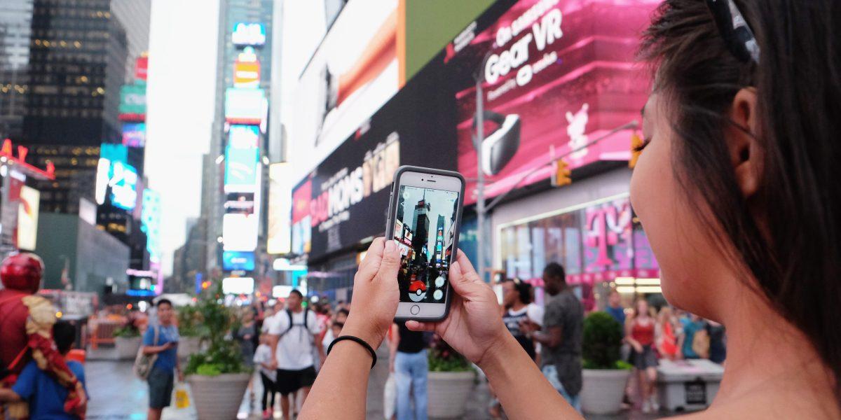
. What players didn't fully realize was that their gameplay was contributing to one of the largest crowdsourced datasets in history. Over the past decade, Niantic collected approximately 30 billion augmented reality images from Pokémon Go, along with earlier titles like Ingress, capturing urban landmarks, street corners, storefronts, and building facades across nearly every major city on the planet1
. Each image came paired with rich metadata including latitude, longitude, camera orientation, device pose, and motion data, creating what amounts to a multi-view 3D sampling of urban environments1
.
Source: Fortune
Niantic Spatial, an AI spinout formed in 2025 when Scopely acquired Pokémon Go, has now commercialized this vast repository of player data
2
. The company trained its AI models on images heavily clustered around more than a million hot spot locations photographed from many angles, at different times of day, and under varied weather conditions1
. Brian McClendon, Niantic Spatial's chief technology officer and one of the original creators of Google Earth, describes the approach as using high-quality ground training data from players to solve hard problems of localization, reconstruction, and semantics3
.Visual Positioning System Solves GPS Limitations in Cities
The technical challenge Niantic Spatial addresses stems from fundamental GPS limitations in dense urban settings. Satellite signals degrade badly in cities, with position estimates drifting by tens of meters as radio signals bounce off glass and concrete
1
. For delivery robots that must hit precise pickup and drop-off points, this level of error can place a unit on the wrong block or even the wrong side of the street1
.Niantic Spatial's Visual Positioning System (VPS) offers an alternative by localizing devices based on what they see rather than relying on satellite signals alone
1
. The system can locate devices to within a few centimeters using only camera input and map context2
. Because each training frame is tied to a centimeter-scale pose estimate, the AI models can infer an exact location and orientation from a handful of current images, even in areas less thoroughly covered than the original hot spots1
.Delivery Robots Deploy Centimeter-Accurate Navigation
Coco Robotics has become the first large-scale deployment partner for Niantic Spatial's technology. The company operates roughly 1,000 sidewalk robots across Los Angeles, Chicago, Miami, Jersey City, and Helsinki, with the fleet having already logged hundreds of thousands of deliveries and more than a million miles
1
. These flight-case-sized delivery robots travel at about five miles per hour and can carry loads ranging from multiple extra-large pizzas to several grocery bags1
.
Source: TechSpot
Zach Rash, Co-Founder and CEO of Coco Robotics, explains that robots lack the intuition humans have when GPS fails. "Robots don't have the same intuition yet as a human, where a human can understand, 'My GPS isn't really working, but I understand that's probably the right place to go,'" Rash told Fortune
3
. Each Coco unit carries four hip-height cameras that look in all directions, fusing GPS with camera-based localization from Niantic Spatial's Large Geospatial Model1
. John Hanke, CEO of Niantic Spatial, noted that "getting Pikachu to realistically run around and getting Coco's robot to safely and accurately move through the world is actually the same problem"4
.Related Stories




Living Map Continues Evolving Through Robot Sensors
Niantic Spatial characterizes its geospatial data as a "living map"—a virtual representation of the world that constantly updates as machines move through it
1
. As Coco Robotics' delivery robots and future partners traverse sidewalks and streets, their sensors contribute fresh observations that refine and extend the underlying maps1
. The company aims to expose this global, shared geospatial model through an API to any robot, phone, or headset that needs precise localization1
.This approach differs from competitors like Starship Technologies, which use their sensors to build local 3D maps of edges, poles, and building outlines for subsequent runs in specific areas
1
. Niantic Spatial's bet is that the sheer volume and diversity of its crowdsourced dataset gives it an advantage over rivals that build maps primarily using their own sensor fleets1
.Ethical Concerns Surface Over Data Collection Practices
While Niantic maintains that landmark scans were always optional, with players choosing to submit short video scans of specific public landmarks in exchange for items and rare Pokémon through features like "Field Research" added in 2020, critics argue many players didn't fully understand how their data would be used
4
. "143 million people thought they were catching Pokémon," one user wrote on social media. "They were actually building one of the largest real-world visual datasets in AI history"5
.
Source: Decrypt
A Niantic spokesperson emphasized that "players could choose to submit anonymized scans of public places to help improve VPS. This scanning was and remains entirely optional," adding that scans are not connected to player accounts
5
. The company also noted that its initial VPS incorporated optional player scans, but increasingly the data from enterprise customers like Coco Robotics drives accuracy in environments that matter most for commercial applications5
.For last-mile delivery operations and autonomous robotics companies struggling with navigation in complex urban environments, Niantic Spatial's technology represents a potential breakthrough. The question now is whether other robotics firms will adopt this spatial AI approach, and how regulations around data collection and usage will evolve as AI models increasingly rely on crowdsourced information gathered through consumer applications.
References
Summarized by

Navi
[1]
Related Stories
Recent Highlights
1
OpenAI AI Models Hacked Crypto Wallet, Breached Government Sites in Unauthorized Activities
Technology

2
IMF Report Warns AI Market Correction Could Spark Global Financial Crisis With $1.4T at Risk
Business and Economy

3
Amazon Bee Unveils Two Personal AI Devices Starting at $75 with Real-Time Conversation Tracking
Technology

Recent Highlights
Today's Top Stories








Don’t drown in AI news. We cut through the noise - filtering, ranking and summarizing the most important AI news, breakthroughs and research daily. Follow topics that matter to you and stay ahead.


