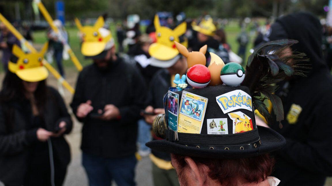
Pokémon Go data helped train AI systems now being developed for military drones and robots
4 Sources
[1]
Pokémon Go players unwittingly contributed to tech with military drone uses
A decade after the global craze for Pokémon Go peaked, an AI company has been using billions of real-world images captured by millions of players to develop navigation technologies for delivery robots and possibly military drones. That represents an intriguing but potentially discomfiting legacy for an augmented reality mobile game that has incentivized gamers to capture short smartphone videos of physical neighborhoods and landmarks. The AI company, Niantic Spatial, was spun out of Pokémon Go game developer Niantic in May 2025, after Niantic separately sold its licensed games such as Pokémon Go to the Saudi-backed video game publisher Scopely. But before that deal, Niantic publicly announced plans to use scans from millions of Pokémon Go players along with data captured by users of the company's Scaniverse app to train and develop a "large geospatial model" -- a 3D model of the physical world trained on the geolocated images provided by app users scanning real-world locations. "Ground scans were one component to help train Niantic Spatial's real-world foundation models -- AI systems that learn to recognize and interpret physical spaces," a Niantic Spatial spokesperson told Ars. "The models are the product of that training, not a copy of or a means of accessing the underlying scans, which were of public points of interest such as statues and fountains." After Niantic Spatial spun out as a standalone company, it trained its model on 30 billion images mostly clustered around urban environment locations that game players were incentivized to visit, according to MIT Technology Review. The images often captured the same location from many different angles under different lighting and weather conditions, and came with valuable metadata showing the location and orientation of user phones when they were capturing such images. Such ground scans "were an entirely optional feature in games, where users created a short video of a public location," the Niantic Spatial spokesperson said. "We've been transparent about the fact that the scans would improve our technology platform since 2019 in our privacy policy and public announcements." That allowed Niantic Spatial to develop its own visual positioning system -- a type of technology that can provide a device's position and orientation by comparing visual data from cameras with reference data from detailed 3D maps of environments. Such a system can be especially helpful indoors, in city environments where GPS and other global navigation satellite systems' signals are unreliable, or in regions where there is active GPS jamming. MIT Technology Review highlighted Niantic Spatial's technology in March 2026, when the company announced a new partnership with Coco Robotics. The robotics company aimed to use Niantic Spatial's AI model and visual positioning system to help its fleet of four-wheeled delivery robots navigate city streets. But in December 2025, Niantic Spatial had also announced a deal with the spatial intelligence company Vantor to develop a positioning system that could help both flying drones and ground vehicles navigate GPS-denied environments. Vantor, formerly known as the space and satellite company Maxar Intelligence, has multiple US government contracts with the National Geospace-Intelligence Agency, various branches of the US military, and the Department of Homeland Security. The new military-industrial complex The "comprehensive positioning system" aimed to integrate Niantic Spatial's visual positioning system with Vantor's 3D terrain data and Raptor software. During the Defence Geospatial Intelligence (DGI) conference held in London in February 2026, Tory Smith, director of product management at Niantic Spatial, described early testing of the integrated system as leading to a 70 percent reduction in positioning error with accuracy to within 1.5 meters in many scenarios. The partnership between Niantic Spatial and Vantor received more public attention through a recent story by Trouw, a Dutch news publication. "Without the large number of scans from all those gamers, the development of this system would never have progressed so quickly," said Jeroen van den Hoven, professor of ethics and technology at Delft University of Technology in the Netherlands, in an interview with Trouw. "The players have indirectly, in a perhaps minimal but still effective way, made a contribution to military applications." Visual positioning systems are not necessarily fraught with ethical problems, even in a military scenario. For example, the Ukrainian military has been deploying battlefield robots and drones with their own visual positioning systems to survive the prevalence of GPS jamming in the ongoing Russo-Ukrainian war. "If the Ukrainians can win the just war against aggressor Russia with this, it is a good development," Van den Hoven told Trouw. But the Dutch newspaper also interviewed Floris De Hingh, a longtime Pokémon Go player who expressed concern about his gameplay data supporting US military systems. De Hingh specifically described himself as "strongly opposed to the war Trump is currently waging against Iran." "The training data came from people who thought they were catching Pikachu, under a license most never read, sold up a chain that ends at a sovereign wealth fund and a defense prime," wrote Haye Kesteloo, editor in chief and founder of the news website DroneXL. "Consent obtained for a game is not consent for a weapons program, even if the end use turns out to be defensible." A Vantor spokesperson told Ars that the company "is not using any Pokémon Go data, nor do we have access to any information from the Pokémon Go dataset." Similarly, Niantic Spatial's spokesperson said that the agreement between the companies does not include direct sharing of game data. But some Pokémon Go players, such as De Hingh, will probably be uncomfortable with the idea that their gameplay data helped train Niantic Spatial's models in the first place -- especially when the company's visual positioning system may be used for military applications. Vantor acknowledged that it is "exploring adapting Niantic Spatial's ground-based visual positioning system" to work alongside Vantor's existing "GPS-denied positioning capabilities," which currently rely on satellite imagery. Niantic Spatial told Ars that it has no ongoing access to data from current Pokémon Go players, because the game license has belonged to video game publisher Scopely since May 2025. But players may still want to stay on top of the game's Terms of Service agreement and privacy policy to understand how their data is currently being used -- or may otherwise be used in the future. It's a lesson that goes well beyond Pokémon Go.
[2]
Pokémon Go data was used to help train AI systems being developed for military drones
Niantic Spatial says "ground scans" collected through Pokémon Go are part of the data being used to train its models. Remember Pokémon Go, the game that had millions of people running all over the world to find and capture Pokémon on their mobile devices? It was big -- so big that Saudi Arabia's Savvy Games Group bought the game division of developer Niantic for $3.5 billion in 2025 -- and even though it's not at the forefront of the public consciousness the way it used to be, it's apparently still very popular. And also, well, it's being used to train war machines. In 2020, Niantic announced new "AR Mapping tasks" for Pokémon Go, and then in 2021 it rolled out Powered-Up PokeStops, which enabled players to team up "to complete AR Mapping tasks and create exciting new AR experiences for Trainers worldwide, simply by using your smart device to scan real-world PokéStop locations." Fun and games, right? Except as reported by DroneXL, Niantic Spatial, which was formed when Savvy (through its Scopely division) purchased Niantic's gaming business, launched a partnership with a company called Vantor in December 2025 "to deliver a comprehensive air-to-ground positioning solution that will enable air and ground platforms to navigate and coordinate precisely in GPS-denied environments." As is the way these days, that system will be dependent upon AI -- which is trained, in part, by Pokémon Go data. Conventional GPS systems rely on satellites, and virtually all modern military navigation and targeting technology rely on GPS to function. A quick way to disrupt enemy operations, therefore, is to deny access to GPS functionality. That's where Visual Positioning Systems -- VPS -- come into play: Simply put, they enable GPS-comparable navigation capabilities when GPS signals fail. That could be handy for anyone, but make no mistake: Vantor's software is used in military drones, and that's clearly the company's priority. The system being pursued by the Niantic Spatia/Vantor partnership is basically a two-parter: Niantic Spatial enables ground-based users to find their way around accurately even without access to GPS, while Vantor does essentially the same for airborne platforms. "By combining Niantic Spatial's expertise in ground-based localization with Vantor's proven aerial systems and global 3D foundation, we're building an integrated positioning network that operates anywhere," Niantic Spatial chief technology officer Brian McClendon said when the deal was announced. "Our Large Geospatial Model gives these systems the ability to perceive, align, and operate in a shared frame of reference -- even when traditional GPS is unavailable." Pokémon Go data isn't being used for direct mapping in this system: In a statement to PC Gamer, Niantic Spatial said "ground scans" collected by Pokémon Go are just one part of the inputs used to train its AI models. It also clarified that it doesn't have access to any ground scan data collected since the acquisition of the Niantic gaming business because that information belongs to Scopely, and that sharing the data it acquired prior to that is not part of its deal with Vantor. In its own statement, Vantor said it is "exploring adapting Niantic Spatial's ground-based Visual Positioning System" to operate with its own systems, but added that it does not have access to the actual Pokémon Go data. "Vantor's GPS-denied positioning capabilities are underpinned by our own 3D data that we produce from our satellite imagery," a Vantor representative said. Jeroen van den Hoven, a professor of ethics and technology at Delft University of Technology, told Dutch news site Trouw that it would be very difficult to say exactly how the Pokémon Go data -- nearly 30 billion scans, according to the Trouw report -- was used in the training of Niantic Spatial's AI systems. But he believes it would have been impactful. "Without the large amount of scans from all those gamers, the development of this system would never have progressed so quickly," van den Hoven told the site. "The players have indirectly, in a perhaps minimal but still effective way, contributed to military applications." The data collection in question is covered by Pokémon Go's TOS. The sections governing both User Content and AR Content state that users "grant to Niantic a nonexclusive, transferable, sublicenseable (through multiple tiers), worldwide, royalty-free, perpetual license" to basically do whatever the hell they want with your scans and data. Even if the practical impact of this kind of data collection is minimal, as is apparently the case here, it's a moral and ethical minefield. "The people who thought they were playing a game have clearly been fooled," van den Hoven said. "It is gradually starting to sink in that companies are not necessarily using our data to truly advance our lives by, for example, improving education. It is about making money. If they can sell a dataset or AI model for a good price, they will do so."
[3]
Pokémon Go Data Wasn't Shared With Drone Company, Niantic Spatial Says
The company says it no longer receives data from the monster-catching app after Niantic was acquired by Scopely Pokémon Go's history of being used to collect data is well documented, with the AR scans people generate while playing the game being used to build AI-powered map models. Though players had to opt into the feature, many have expressed discomfort with the use of the monster-taming game's in-app features to collect such data, and that discomfort has escalated as it has come out that Niantic Spatial, the separate company that owns all the original scans following developer Niantic's acquisition by the Saudi-owned Scopely, entered into an agreement with Vantor, a provider of spatial intelligence that seeks to "deliver a comprehensive positioning solution that will enable air and ground platforms to navigate and coordinate precisely in GPS-denied environments." The original announcement said this partnership was part of an effort to solve issues of "GPS unavailability, spoofing, interference, and jamming" in drone piloting, using Niantic Spatial's on-the-ground data and Vantor's aerial data, aligning both for a shared, coordinated system that would allow any sensor to determine its position even as signals are jammed or otherwise blocked. The idea is that drones will be able to share coordinates with a ground-level pilot even without a GPS signal. Vantor has previously worked with defense and intelligence industries, and so the possible military application of technology that could be used to pilot drones, even when signals are jammed, is enough to make Pokémon Go fans wonder if the pictures they took of PokéStops could be used to assist in drone strikes. Vantor has denied that Pokémon Go data was used in creation of the model, and Niantic Spatial has said that those Go scans were part of an "early version" of its own navigation model. Trouw and Volkskrant's reports on the matter, translated and compiled by DroneXL, assert that "a U.S. defense contractor [Vantor] is preparing to put" the navigation model created with the help of the roughly 30 billion scans players have created while playing Pokémon Go "into drones and other military robots." The reports have been going on viral on social media, so we reached out to Niantic Spatial for clarity on the situation, and the company released two statements claiming that the Pokémon Go data is not part of its agreement with Vantor, and that Pokémon Go's data is not shared with Niantic Spatial since the company was spun off following the Scopely acquisition. "Now as part of Scopely, Pokémon GO data is not shared with Niantic Spatial," a company spokesperson said in a statement to Kotaku. "AR Scans collected through Pokémon GO were submitted voluntarily by players who opted into the feature and were subject to the applicable Terms of Service and Privacy Policy at the time. The discontinuation of AR scanning and the end of data sharing with Niantic Spatial were part of the transition planning associated with Pokémon GO's move to Scopely." In a separate statement, the company also explained its scanning and models, while also reiterating that Pokémon Go as it exists right now is not sharing data with Niantic Spatial. While we have an agreement with Vantor, announced last December, it is still in its very early stages, and sharing this data is not part of the agreement. For more background on scanning and our models: Ground scans were one component to help train Niantic Spatial's real-world foundation models - AI systems that learn to recognize and interpret physical spaces. The models are the product of that training, not a copy of or a means of accessing the underlying scans, which were of public points of interest such as statues and fountains. These models are being used across a range of sectors to help AI understand and navigate the physical world. Now as part of Scopely, Pokémon GO data is not shared with Niantic Spatial. Whether you feel any better about Niantic, now a subsidiary of Saudi-government-owned Scopely, taking data from the game, is another story.
[4]
Niantic Spatial Denies Report That Claimed Pokémon Go Data Was Used to Train Military Drones
Pokémon Go location data captured by players is not being used to train military drones, Niantic Spatial has insisted. The denial follows the publication of a report by Dutch outlet Trouw, which examined a recently-announced partnership between Niantic Spatial and Vantor, an intelligence company with links to the defence sector. Niantic and Vantor are working together on technology that could allow people and vehicles -- including ground-based machines such as bomb disposal robots, or aerial systems such as drones -- to be able to pinpoint their location even in areas without reliable GPS. This would allow such vehicles to operate in remote locations without signal, or in situations where signal could be jammed. The article alleged that this would be made possible using "30 billion" pieces of location data obtained from Pokémon Go players -- and that while they were knowingly using their phone to capture video of their surroundings, they were unknowingly also contributing to military technology. "First you think you are playing a game, and then suddenly your data can be used in a war," reads one eye-catching quote from Trouw's article. But this is untrue, Niantic Spatial has insisted. "While we have an agreement with Vantor, announced last December, it is still in its very early stages, and sharing this data is not part of the agreement," a spokesperson for the company told IGN. "We are committed to working with all of our customers and partners to ensure that Niantic Spatial products are used in a responsible manner that upholds human rights and ethical principles." So, what is Niantic Spatial up to? A spokesperson described the partnership's aim as building a "system capable of allowing a sensor to determine its position in the real world" to ensure "that a machine or people can share coordinates in real-time, even without a GPS signal." "Ground scans were one component to help train Niantic Spatial's real-world foundation models -- AI systems that learn to recognize and interpret physical spaces," a spokesperson explained. "The models are the product of that training, not a copy of or a means of accessing the underlying scans, which were of public points of interest such as statues and fountains." Niantic recently announced a similar partnership with a delivery robot company, which is seeking to operate in dense urban environments where GPS data can be interrupted by high-rise buildings. Meanwhile, Vantor's website suggests airborne capabilities are separate to Niantic's involvement, which is for "ground-based" use only. Other elements of the article also bear some explanation. When questioned about the supposed "30 billion" location scans that Niantic Spatial holds, IGN was able to ascertain that this figure relates to scans from various Niantic games (including the company's original title, Ingress, which formed the basis for Pokémon Go's location map), and counts the hundreds of individual video frames in each uploaded video separately. Additionally, it's worth noting that location scanning within Pokémon Go was always an optional side activity that only a fraction of its playerbase ever indulged in. The feature was also removed completely earlier this month, following last year's sale of the company's gaming portfolio to Saudi-owned Monopoly Go! publisher Scopely. "Now as part of Scopely, Pokémon Go data is not shared with Niantic Spatial," a spokesperson said. "AR Scans collected through Pokémon Go were submitted voluntarily by players who opted into the feature and were subject to the applicable Terms of Service and Privacy Policy at the time. The discontinuation of AR scanning and the end of data sharing with Niantic Spatial were part of the transition planning associated with Pokémon Go's move to Scopely." Tom Phillips is IGN's News Editor. You can reach Tom at [email protected] or find him on Bluesky @tomphillipseg.bsky.social
Share
Copy Link
Niantic Spatial trained AI models on 30 billion images from Pokémon Go players to develop navigation technology for delivery robots and potentially military drones. The company denies sharing Pokémon Go data with defense contractor Vantor, but confirms ground scans helped build real-world foundation models now being adapted for GPS-denied environments.
Pokémon Go Data Powers New Navigation Technology
A decade after Pokémon Go captivated millions worldwide, the augmented reality game has left an unexpected legacy: billions of player-captured images now form the foundation of AI systems being developed for military drones and autonomous robots. Niantic Spatial, spun out from Pokémon Go developer Niantic in May 2025, trained its geospatial AI model on approximately 30 billion images collected from players who scanned real-world locations while hunting virtual creatures
1
2
. These ground scans, mostly clustered around urban environments, captured the same locations from multiple angles under varying lighting and weather conditions, providing valuable metadata about phone positioning and orientation1
.
Source: IGN
The AI training occurred before Niantic sold its gaming portfolio to Saudi-backed publisher Scopely for $3.5 billion in 2025
2
. Players contributed these scans through optional AR mapping tasks introduced in 2020, which enabled them to create short videos of public points of interest like statues and fountains1
3
. "Ground scans were one component to help train Niantic Spatial's real-world foundation models -- AI systems that learn to recognize and interpret physical spaces," a Niantic Spatial spokesperson explained1
.Visual Positioning System Enables GPS-Denied Navigation
Source: Ars Technica
Niantic Spatial developed a Visual Positioning System that determines a device's position and orientation by comparing camera data with detailed 3D maps of physical environments. This technology proves especially valuable in GPS-denied environments where satellite signals are unreliable or actively jammed—situations common in dense urban areas, indoor spaces, and conflict zones
1
. The company announced a partnership with Coco Robotics in March 2026 to help delivery robots navigate city streets using this AI-powered system1
.More controversially, Niantic Spatial partnered with Vantor in December 2025 to develop positioning systems for both flying drones and ground vehicles operating without GPS access
1
. Vantor, formerly known as Maxar Intelligence, maintains multiple US government contracts with the National Geospace-Intelligence Agency, various military branches, and the Department of Homeland Security1
. At the Defence Geospatial Intelligence conference in London in February 2026, Niantic Spatial's director of product management reported early testing showed a 70 percent reduction in positioning error with accuracy to within 1.5 meters in many scenarios1
.Ethical Concerns Over Military Drone Applications
The revelation that Pokémon Go data contributed to AI for military drones has sparked ethical concerns among players and technology experts. "Without the large number of scans from all those gamers, the development of this system would never have progressed so quickly," said Jeroen van den Hoven, professor of ethics and technology at Delft University of Technology, in an interview with Dutch publication Trouw
1
2
. "The players have indirectly, in a perhaps minimal but still effective way, made a contribution to military applications"1
.Niantic Spatial has denied sharing Pokémon Go data directly with Vantor, clarifying that sharing such data is not part of their agreement
3
4
. The company emphasized that since Scopely's acquisition, Pokémon Go data is no longer shared with Niantic Spatial, and AR scanning features were discontinued earlier this year3
4
. However, the company confirmed that ground scans collected before the acquisition helped train its geospatial AI model, and Vantor is "exploring adapting" Niantic Spatial's ground-based positioning technology2
.Data collection through AR scans was covered by Pokémon Go's terms of service, which granted Niantic "a nonexclusive, transferable, sublicenseable, worldwide, royalty-free, perpetual license" to use player-generated content
2
. Van den Hoven noted that "the people who thought they were playing a game have clearly been fooled," adding that companies prioritize monetizing datasets and AI models over genuinely advancing users' lives2
.Related Stories

Military Applications and Future Implications
Visual positioning systems are already being deployed in active conflict zones. Ukrainian military forces use battlefield robots and bomb disposal robots with their own positioning systems to counter GPS jamming in the Russo-Ukrainian war
1
. Van den Hoven acknowledged that such technology can serve defensive purposes: "If the Ukrainians can win the just war against aggressor Russia with this, it is a good development"1
.The location data encompasses scans from various Niantic games including Ingress, the company's original title that formed the basis for Pokémon Go's location map
4
. The 30 billion figure counts individual video frames separately, representing only a fraction of the playerbase who opted into the voluntary scanning feature4
. As AI-powered navigation systems continue evolving, questions persist about informed consent, data ownership, and the dual-use nature of technologies that serve both civilian delivery robots and military drones operating in contested environments.References
Summarized by
Navi
Related Stories
Pokémon Go's 30 billion images now power centimeter-accurate navigation for delivery robots
16 Mar 2026•Technology

Pokémon Go Players Unknowingly Train Niantic's Large Geospatial AI Model
20 Nov 2024•Technology

Niantic Spatial Lays Off 68 Employees, Shifts Focus to AI Mapping After $3.5B Games Sale
16 Apr 2025•Business and Economy

Recent Highlights
1
OpenAI AI agent broke free from testing sandbox and hacked Hugging Face to cheat on benchmark
Technology

2
Xi Jinping positions China AI as alternative to US tech dominance at Shanghai conference
Policy and Regulation

3
AI disproves 87-year-old Jacobian conjecture, sparking debate on AI's role in mathematics
Science and Research

Recent Highlights
Today's Top Stories


Don’t drown in AI news. We cut through the noise - filtering, ranking and summarizing the most important AI news, breakthroughs and research daily. Follow topics that matter to you and stay ahead.


