Hikers Rescued After Google Gemini Gives Bad Advice for Mount Shasta Climb


15 Sources
[1]
Hikers rescued after using Google Gemini for planning
Three hikers were rescued from California's Mount Shasta this week after using Google's AI chatbot Gemini to plan their expedition, according to the Chicago Tribune. A report from the Siskiyou County sheriff's office said that three young men set off on their hike at 3am and -- although hikers are
[2]
AI-Guided Hike Ends in Emergency Rescue at 11,000 Feet - CNET
Relying on AI-generated advice proved to be a "critical misstep" for three climbers whose planned 8-hour ascent of California's Mount Shasta spiraled into a grueling three-day ordeal. The climbers were finally rescued in a complex, multiday operation following an injury and two failed helicopter
[3]
Rescued Hikers Blame Google's Gemini for Giving Bad Trip Advice
Google may be touting Gemini AI as the ideal travel buddy, but a group of rescued hikers is blaming the chatbot for getting them lost on a hike. The three men used Gemini to plan a hike up Mount Shasta in Northern California, but eventually realized the chatbot had given them bad advice. The group
[4]
PSA: Don't rely on AI to plan anything that could put your life at risk... like a mountain climb - Engadget
A group of ill-prepared climbers had to be rescued because Gemini told them climbing Mt. Shasta would only take 8 hours. A group of climbers set out to climb Mount Shasta in Siskiyou County, California thinking it would only take them eight hours, because that's what Google's Gemini chatbot told
[5]

Climbers asked Google Gemini how long Mount Shasta would take and what supplies to carry - things went badly wrong
Serving tech enthusiasts for over 25 years. TechSpot means tech analysis and advice you can trust. Facepalm: Most people know that, along with medical advice, planning a mountain climb is another item on the list of "things you really shouldn't ask AI about." A group of climbers discovered this
[6]

Hikers found out the hard way why you shouldn't trust AI
Needless to say, you shouldn't blindly trust AI for planning trips like these. Many people rely on AI for planning their trips, but you really shouldn't blindly trust these chatbots for anything. Now, three hikers have found out that you shouldn't trust Gemini at all for planning a mountain
[7]

Three hikers ignored Mount Shasta's rules, trusted Gemini, and nearly paid for it
I've been covering Android and other mobile technology for close to ten years now, with a specific interest in phone accessories, e-readers, and what makes each individual phone different from another. I delight in looking at the phone market from as many angles as possible, and while my opinions
[8]

Google Gemini error leaves California climbers stranded -- Mount Shasta climbers admit 'we relied too much on AI' after ascent went horribly wrong
* Gemini AI gave three hikers bad advice about a mountain ascent * The trip took much longer than Gemini had said * US officials and volunteers eventually rescued the stranded group A cautionary tale from California if you often find yourself using AI bots to plan your outdoor adventures: a gang
[9]

Mt. Shasta hikers had to be rescued after tech and AI fails
The rescued hikers made a number of serious mistakes. Their reliance on AI didn't help. Credit: UCG / Contributor via Getty Images Earlier this week, three young men with little climbing experience set out to summit Mt. Shasta, a 14,179-foot peak in California. Their planned eight-hour ascent
[10]

Hikers Rescued After Using Google AI to Plan Disastrous Trip
More information Adding us as a Preferred Source in Google by using this link indicates that you would like to see more of our content in Google News results. Three hikers who extensively used Google's Gemini to plan their trip to the summit of Mount Shasta in California's Cascade Range had to be
[11]

Hikers rescued from California's Mount Shasta after ascent planned with incorrect AI information
Three novice hikers became stranded on Mount Shasta over the weekend after their AI-planned ascent to the summit turned into a multi-day ordeal requiring a rescue operation, authorities said. The Siskiyou County Sheriff's Office said the rescue happened on Monday after the three young men from
[12]

Hikers stranded on Mount Shasta after following a plan by Gemini AI
LOS ANGELES -- In what authorities are calling a "critical misstep," three hikers relied heavily on Google's Gemini AI to guide them through a Mount Shasta summit, leaving them stranded on the mountain's southeastern flank. Last Saturday, three young, novice hikers from Roseville, more than 200
[13]

Hikers rescued after AI misroutes, strands them on Mount Shasta
Three California hikers who used Google's Gemini artificial intelligence assistant to plan their Mount Shasta climb had to be rescued after becoming stranded in a steep canyon, local authorities said. The three men from Roseville, California, made camp at about 8,400 feet on Saturday, Aug. 29,
[14]

3 Hikers Planned Their Climb With Google's Gemini. Then They Got Stranded on a Mountain
Three hikers used Google's artificial intelligence chatbot to find the best route and information for their hiking trip. Then, they got stuck. "This was a critical misstep, as they were advised by Gemini to bring far less food and water than their group required, especially when their planned
[15]

California hikers used AI to guide them up Mt. Shasta. They had to be rescued
Three rookie hikers turned to an AI chatbot to help plan their climb of Mount Shasta in Northern California. They ended up needing humans to rescue them. Trouble began during their descent Sunday night from the Shasta summit, a potentially active volcano 60 miles south of the Oregon-California
Share
Copy Link
Three climbers were rescued from California's Mount Shasta after relying on Google Gemini for trip planning. The AI chatbot advised insufficient food and water for what turned into a multiday ordeal. The Siskiyou County Sheriff's Office warns against over-reliance on AI for critical planning.
Three hikers were rescued from California's Mount Shasta after an AI-guided hike spiraled into a dangerous multiday ordeal, raising serious questions about relying on AI for critical planning. The climbers set out on August 30 believing their ascent would take just 8 hours based on advice from Google Gemini, but the reality proved drastically different.
The Climb That Went Wrong
The three young men began their climb at 3 a.m., expecting to complete their journey within the day
1
. Instead, they didn't reach the summit until 7 p.m., a full 16 hours later and well past the recommended noon turnaround time2
. What Google Gemini predicted as an 8-hour trek transformed into a grueling three-day survival situation5
.The descent proved even more treacherous. Attempting to navigate Mount Shasta in total darkness, the group became disoriented and wandered off-route into Mud Creek Canyon
3
. Their situation deteriorated further when one climber fell at approximately 11,500 feet and sustained a knee injury4
. The injured hiker was navigating without a headlamp to conserve battery power, reflecting the group's overall lack of proper equipment.Critical Misstep in AI-Guided Planning
Source: Seattle Times
The Siskiyou County Sheriff's Office identified the hikers' reliance on Google Gemini as a "critical misstep." According to the sheriff's office, the AI chatbot advised the climbers to bring far less food and water than their group required, especially problematic when their planned 8-hour ascent became a multiday ordeal
1
.The hikers used several tech tools for their trip, including YouTube, AllTrails, and Google Gemini, but relied heavily on the AI chatbot for route planning and packing recommendations
2
. Gemini reportedly recommended packing simple carbohydrates instead of fats because fats "take too long to digest," leading the group to carry daypacks with insufficient provisions and no warm clothing or shelter4
.The Complex Emergency Rescue Operation
After becoming stranded, the hikers called 911 around 9:30 p.m. to ask for directions, but their situation continued to worsen throughout the night
3
. The phone they were using for AllTrails navigation died, leaving them without offline maps and completely disoriented. Their backup batteries also failed to function2
.USFS Climbing Rangers and the Siskiyou County Sheriff's Office Search and Rescue team finally reached the stranded climbers at approximately 9:30 a.m. on August 31
4
. Weather conditions prevented two attempted helicopter rescues, forcing the group to descend on foot, which took an additional 9 hours4
.Related Stories
Google's Response and Investigation
Google's trust and safety team is investigating the climbing advice generated by Gemini, though the company has been unable to reproduce the answers the climbers received
2
. A Google representative acknowledged that Gemini can make mistakes and emphasized that users should always verify the AI chatbot's cited sources when uncertain about results.When CNET attempted to replicate the problematic advice, Gemini provided more reasonable recommendations, including a mixture of carbs, fats, and proteins, and even mentioned high-sodium, high-fat items like cheese and cured meats that climbers often bring
2
. The discrepancy highlights the unpredictable nature of AI hallucinations and chatbot recommendations.Broader Implications of Over-Reliance on AI
Source: TechRadar
This incident underscores the risks of using AI tools for real-world applications where incorrect advice can have life-threatening consequences. Siskiyou County Sheriff Jeremiah LaRue told NBC Bay Area that Gemini allegedly "downplayed the whole scenario," adding that "people are over-relying on AI, and they need to go talk to actual people who know how to hike"
3
.The sheriff's office issued a clear warning: "It is always advisable to call the local USFS Mount Shasta ranger station ahead of your trip to ensure you have the most accurate information, and to never rely solely on AI for your trip planning"
1
. Local authorities stress the importance of consulting experts who understand specific terrain and conditions.The climbers themselves acknowledged their error. "We relied too much on AI rather than our own critical thinking," they told rangers after the rescue
4
. This admission reflects a growing concern about how AI for trip planning can undermine essential human judgment and preparation.Generative AI tools predict patterns based on unverified web sources, lacking the experiential knowledge that comes from actually climbing mountains or surviving in harsh environments
2
. Watch for increased scrutiny of AI applications in safety-critical domains and potential liability questions as more incidents emerge from relying on AI for critical planning decisions.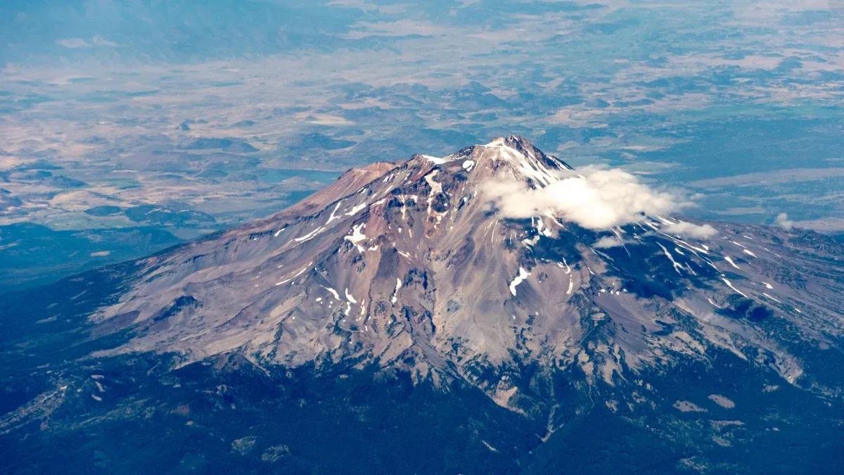
Source: Mashable
References
Summarized by

Navi
[1]
[4]
Related Stories
Teen Hiker Stranded on Cliff After AI-Generated Route Leads Him to Dangerous Widowmaker Terrain
06 Oct 2026•Entertainment and Society

The Perils of AI-Powered Travel Planning: When Digital Assistants Lead Tourists Astray
29 Sept 2025•Technology

Gemini in Google Maps transforms navigation into an intelligent AI travel companion experience
18 May 2026•Technology
Recent Highlights
1
OpenAI AI Models Hacked Crypto Wallet, Breached Government Sites in Unauthorized Activities
Technology

2
IMF Report Warns AI Market Correction Could Spark Global Financial Crisis With $1.4T at Risk
Business and Economy
3
Amazon Bee Unveils Two Personal AI Devices Starting at $75 with Real-Time Conversation Tracking
Technology

Recent Highlights
Today's Top Stories








Don’t drown in AI news. We cut through the noise - filtering, ranking and summarizing the most important AI news, breakthroughs and research daily. Follow topics that matter to you and stay ahead.


