Greece deploys AI-powered satellite constellation to detect wildfires in global first
2 Sources
[1]
Suitcase-sized satellites are scanning for Greek wildfires in a global first
ATHENS, Greece (AP) -- In the searing Mediterranean summer, wildfires turn dangerous in minutes. Greece has learned that at a terrible cost. In 2018, a blaze east of Athens moved with ferocious speed, killing more than 100 people. Five years later, a massive fire tore through a remote nature reserve; it was the largest wildfire ever recorded in the European Union. Greece is looking to the heavens for help, with a dedicated satellite constellation that monitors for fires. It's a model for the continent as Europe races toward broader independence in space technology. Four satellites, each smaller than a piece of carry-on luggage, were launched into low orbit in May. That made Greece the first nation in the world to integrate a dedicated satellite array into its national firefighting system. Built by German company OroraTech, the satellites carry thermal sensors designed to flag new blazes as small as four meters (13 feet) wide, beating traditional satellites that can only spot fires the size of a cruise ship. Satellites help manage multiple wildfires As Europe struggles with its latest blistering heatwave, the high temperatures foreshadow the wildfire season. Fires pose a unique challenge in Greece with its tinder-dry mountainous mainland and over 100 inhabited islands. If a fire ignites, AI-processed satellite data is sent as an alert to commanders with the location, size and intensity already calculated. If multiple fires are burning at once, real-time data is crucial to determining response. "For example, if you have 10 fires all over Greece and the fire radiative power is lower in some cases, you will not give priority to those ignitions; you will give priority to other ones," Fire Service Col. Zisoula Ntasiou, vice president of the International Association of Fire and Rescue Services, told The Associated Press in an interview. Thermal sensors also pick up solar panels, hot factory roofs and sunbaked rock faces, but AI models are built to filter out those false alarms before alerts reach emergency services, according to officials involved in the program. Hotter summers require better AI models Greece recorded its hottest summer on record in 2024 and its third-hottest last year. "The global temperature is going up. That causes fires to change in intensity and ferocity," Ioannis Lantouris, head of OroraTech's Greek operations, told the AP. "Our models have to change and adjust to that. They have to be faster. They have to be more precise." Lantouris spoke in his office in Athens, while engineers worked on fire behavior models. Near their desks, they keep a life-sized replica of the satellite. Thermal satellites add a layer of detection to drones and ground sensors, and Greece has expanded both since the 2018 disaster forced an overhaul of wildfire response. The constellation helps fill coverage gaps from international satellites, spot fires in remote terrain and build more detailed models of fire behavior. Multiple countries use thermal satellites but Greece is the first to fully integrate them into its firefighting system. The satellites themselves mark an early stage of a broader Europe-backed effort. Greece is building a wider observation network with three European companies, combining thermal satellites, radar satellites capable of seeing through clouds and smoke, and optical satellites that capture highly detailed imagery of the ground. That network carries a total price tag of 200 million euros ($227 million) and is funded by the EU. Falling costs for launch and manufacturing have made the expansion possible. Additional satellite deployments are planned by the end of the year. Future ideas include border surveillance Planners in Athens and across Europe already envision applying the same kind of network far beyond fire detection. Future systems will support border surveillance, crop management, disaster response and heat-wave planning. One priority is identifying urban "heat islands," allowing authorities to target cooling centers and emergency services more effectively. The ambitions follow a strategic shift to seek greater technological independence. Rattled by Russia's war in Ukraine and strained trans-Atlantic ties, European governments are reducing dependence on foreign technology. Space infrastructure has become a pillar of that effort. Greece's satellite network is part of a European push linking launch vehicles, navigation systems, Earth observation networks and secure communications into a more sovereign technological ecosystem. The goal, officials say, is to move beyond satellite imagery as a passive tool and develop near-real-time decision systems that help governments manage crises as they happen. The blazing Greek summer will offer an initial test.
[2]
Greece tackles climate change wildfire risk with satellite network that can spot a blaze the size of a parking space | Fortune
In the searing Mediterranean summer, wildfires turn dangerous in minutes. Greece has learned that at a terrible cost. In 2018, a blaze east of Athens moved with ferocious speed, killing more than 100 people. Five years later, a massive fire tore through a remote nature reserve; it was the largest wildfire ever recorded in the European Union. Greece is looking to the heavens for help, with a dedicated satellite constellation that monitors for fires. It's a model for the continent as Europe races toward broader independence in space technology. Four satellites, each smaller than a piece of carry-on luggage, were launched into low orbit in May. That made Greece the first nation in the world to integrate a dedicated satellite array into its national firefighting system. Built by German company OroraTech, the satellites carry thermal sensors designed to flag new blazes as small as four meters (13 feet) wide, beating traditional satellites that can only spot fires the size of a cruise ship. Satellites help manage multiple wildfires As Europe struggles with its latest blistering heatwave, the high temperatures foreshadow the wildfire season. Fires pose a unique challenge in Greece with its tinder-dry mountainous mainland and over 100 inhabited islands. If a fire ignites, AI-processed satellite data is sent as an alert to commanders with the location, size and intensity already calculated. If multiple fires are burning at once, real-time data is crucial to determining response. "For example, if you have 10 fires all over Greece and the fire radiative power is lower in some cases, you will not give priority to those ignitions; you will give priority to other ones," Fire Service Col. Zisoula Ntasiou, vice president of the International Association of Fire and Rescue Services, told The Associated Press in an interview. Thermal sensors also pick up solar panels, hot factory roofs and sunbaked rock faces, but AI models are built to filter out those false alarms before alerts reach emergency services, according to officials involved in the program. Hotter summers require better AI models Greece recorded its hottest summer on record in 2024 and its third-hottest last year. "The global temperature is going up. That causes fires to change in intensity and ferocity," Ioannis Lantouris, head of OroraTech's Greek operations, told the AP. "Our models have to change and adjust to that. They have to be faster. They have to be more precise." Lantouris spoke in his office in Athens, while engineers worked on fire behavior models. Near their desks, they keep a life-sized replica of the satellite. Thermal satellites add a layer of detection to drones and ground sensors, and Greece has expanded both since the 2018 disaster forced an overhaul of wildfire response. The constellation helps fill coverage gaps from international satellites, spot fires in remote terrain and build more detailed models of fire behavior. Multiple countries use thermal satellites but Greece is the first to fully integrate them into its firefighting system. The satellites themselves mark an early stage of a broader Europe-backed effort. Greece is building a wider observation network with three European companies, combining thermal satellites, radar satellites capable of seeing through clouds and smoke, and optical satellites that capture highly detailed imagery of the ground. That network carries a total price tag of 200 million euros ($227 million) and is funded by the EU. Falling costs for launch and manufacturing have made the expansion possible. Additional satellite deployments are planned by the end of the year. Future ideas include border surveillance Planners in Athens and across Europe already envision applying the same kind of network far beyond fire detection. Future systems will support border surveillance, crop management, disaster response and heat-wave planning. One priority is identifying urban "heat islands," allowing authorities to target cooling centers and emergency services more effectively. The ambitions follow a strategic shift to seek greater technological independence. Rattled by Russia's war in Ukraine and strained trans-Atlantic ties, European governments are reducing dependence on foreign technology. Space infrastructure has become a pillar of that effort. "These technologies support civil protection, security and, where necessary, defense-related applications," Dimitris Papastergiou, Greece's minister of digital governance, said in an interview at his office in Athens. "The knowledge generated through these investments should remain in Europe and be combined with other European capabilities, including telecommunications and AI infrastructure," he said. Papastergiou announced Friday that the EU is planning to further boost funding for the Greek programs with an additional 350 million euros. Greece's satellite network is part of a European push linking launch vehicles, navigation systems, Earth observation networks and secure communications into a more sovereign technological ecosystem. The goal, officials say, is to move beyond satellite imagery as a passive tool and develop near-real-time decision systems that help governments manage crises as they happen. The blazing Greek summer will offer an initial test.
Share
Copy Link
Greece became the first nation to integrate a dedicated satellite array into its national firefighting system, launching four suitcase-sized satellites in May. Built by German company OroraTech, these thermal sensors can detect blazes as small as four meters wide and send real-time alerts to emergency commanders. The €200 million EU-funded project addresses climate change wildfire risk following deadly fires in 2018 and 2023.
Greece Wildfires Drive Historic Satellite Deployment
Greece has become the first nation in the world to fully integrate a dedicated satellite constellation into its national firefighting system, marking a significant advance in wildfire detection technology. Four suitcase-sized satellites were launched into low orbit in May, each carrying thermal sensors capable of flagging new blazes as small as four meters (13 feet) wide
1
. This precision far exceeds traditional satellites that can only spot fires the size of a cruise ship, addressing a critical gap in early detection that has cost lives in the Mediterranean nation.The deployment comes after Greece experienced devastating losses from wildfires. In 2018, a blaze east of Athens killed more than 100 people, moving with ferocious speed that overwhelmed emergency response
1
. Five years later, the largest wildfire ever recorded in the European Union tore through a remote nature reserve2
. These tragedies forced an overhaul of Greece's wildfire response, with the satellite constellation representing the latest layer in a multi-tiered detection system.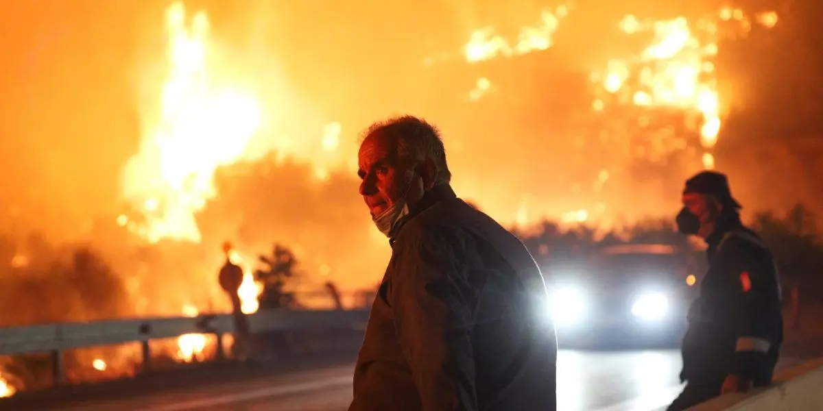
Source: Fortune
AI Models Filter False Alarms and Prioritize Response
Built by German company OroraTech, the satellites deliver AI-processed data as real-time alerts to fire commanders, with location, size, and intensity already calculated
1
. This AI-driven decision-making capability proves crucial when multiple fires burn simultaneously across Greece's tinder-dry mountainous mainland and over 100 inhabited islands. "For example, if you have 10 fires all over Greece and the fire radiative power is lower in some cases, you will not give priority to those ignitions; you will give priority to other ones," Fire Service Col. Zisoula Ntasiou, vice president of the International Association of Fire and Rescue Services, explained1
.Thermal sensors inevitably pick up heat signatures from solar panels, hot factory roofs, and sunbaked rock faces. However, AI models are specifically built to filter out these false alarms before alerts reach emergency services
2
. As climate change wildfire risk intensifies—Greece recorded its hottest summer on record in 2024—these models must continuously adapt. "The global temperature is going up. That causes fires to change in intensity and ferocity," said Ioannis Lantouris, head of OroraTech's Greek operations. "Our models have to change and adjust to that. They have to be faster. They have to be more precise"1
.
Source: AP
EU-Funded Project Expands to €550 Million Network
The satellite constellation forms part of a broader €200 million ($227 million) EU-funded project that combines thermal satellites with radar satellites capable of seeing through clouds and smoke, plus optical satellites capturing highly detailed ground imagery
1
. Greece is building this wider observation network with three European companies, with additional satellite deployments planned by the end of the year. Falling costs for launch and manufacturing have made this expansion possible.The EU plans to further boost funding for Greek programs with an additional €350 million, bringing total investment to €550 million
2
. "These technologies support civil protection, security and, where necessary, defense-related applications," said Dimitris Papastergiou, Greece's minister of digital governance. "The knowledge generated through these investments should remain in Europe and be combined with other European capabilities, including telecommunications and AI infrastructure"2
.Related Stories

Near-Real-Time Crisis Management and Future Applications
Planners in Athens and across Europe envision applying this network far beyond wildfire detection. Future systems will support border surveillance, crop management, disaster response, and heat-wave planning
1
. One priority involves identifying urban "heat islands," allowing authorities to target cooling centers and emergency services more effectively during extreme weather events.This shift toward near-real-time crisis management represents a strategic pivot for Europe. Rattled by Russia's war in Ukraine and strained trans-Atlantic ties, European governments are pursuing greater technological independence, with space infrastructure becoming a pillar of that effort
1
. The goal is to move beyond satellite imagery as a passive tool and develop active decision systems that help governments manage crises as they happen. As Europe faces another blistering heatwave, the blazing Greek summer will offer an initial test of whether this vision can translate into lives saved and disasters averted.References
Summarized by
Navi
Related Stories
Google-Backed AI Satellite Constellation Aims to Revolutionize Global Wildfire Detection
19 Sept 2024

Google's FireSat: AI-Powered Satellite Constellation Launches to Revolutionize Wildfire Detection
18 Mar 2025•Technology

Google Backs AI-Powered Satellite Constellation for Early Wildfire Detection
17 Sept 2024

Recent Highlights
1
Xi Jinping positions China as global AI partner while challenging US tech dominance
Policy and Regulation
2
Moonshot AI releases Kimi K3, China's largest AI model challenging OpenAI and Anthropic
Technology

3
Apple releases Siri AI to everyone through iOS 27 public beta, marking biggest assistant overhaul
Technology

Recent Highlights
Today's Top Stories


Don’t drown in AI news. We cut through the noise - filtering, ranking and summarizing the most important AI news, breakthroughs and research daily. Follow topics that matter to you and stay ahead.


